Welcome to DU!
The truly grassroots left-of-center political community where regular people, not algorithms, drive the discussions and set the standards.
Join the community:
Create a free account
Support DU (and get rid of ads!):
Become a Star Member
Latest Breaking News
General Discussion
The DU Lounge
All Forums
Issue Forums
Culture Forums
Alliance Forums
Region Forums
Support Forums
Help & Search
General Discussion
Related: Editorials & Other Articles, Issue Forums, Alliance Forums, Region ForumsYale Environment 360: On the Alabama Coast, the Unluckiest Island in America
Dauphin Island has been battered by more than a dozen hurricanes and tropical storms in recent decades. But that hasn’t stopped homeowners on the beach resort from repeatedly getting federal aid and insurance payouts to keep rebuilding in the same vulnerable locations.
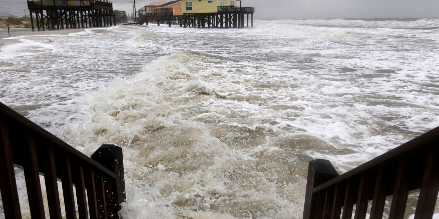
On the night of September 12, 1979, a bruising Category 3 hurricane named Frederic roared up the Gulf of Mexico and across Alabama’s Dauphin Island before surging into Mobile Bay. The 120-mile-per-hour winds and 12-foot storm surge toppled the only bridge to the island and destroyed 140 houses. For several years, the only way for workers to commute to nearby Mobile was by ferry.
Travel guides from the era described Dauphin Island as one of the Gulf’s hidden gems, a quaint, unpretentious oasis of pastel bungalows, white sugar-sand beaches, and spectacular sunsets. They didn’t mention hurricanes or the fact that the 14-mile island was slowly sinking into the Gulf of Mexico.
Dauphin is shaped like a drumstick – widest on its east end, where there is a lush maritime forest, a historic Civil War–era fort, and a nationally celebrated bird sanctuary; and pinched on its west end, where it has lost over 100 feet of shoreline to erosion and storms in the last few decades, and vacation houses now perch like birdhouses above the water. It is one of a score of low-lying islands, some no more than sand spits, which dangle like a necklace along the Gulf Coast from Alabama to Louisiana. Once a formidable barrier between the Gulf and the mainland, the islands are now tattered and uneven, some dense with sedge and trees, others ripped asunder by storms and all but vanished beneath the water.
Frederic wasn’t the first hurricane to pummel the Alabama resort, nor would it be the last. For as long as anyone has kept records, Dauphin Island has been a magnet for violent storms. In the early 1900s, five powerful hurricanes lashed the then mostly empty barrier. More recently, a dozen hurricanes and tropical storms have battered the resort, including Camille in 1969, Frederic in 1979, Georges in 1998, Ivan in 2004, and Katrina in 2005. In 2017, Nate, a weak storm with 65-mile-per-hour winds, pushed several feet of water into dozens of homes.
...
Now, with the planet warming, sea levels rising, and oceans heating up, providing more fuel, hurricanes are likely to grow even larger and more destructive in the future, says Kerry Emanuel, one of the leading atmospheric scientists and hurricane experts, based at MIT. By the next century, a Category 5 hurricane – such as Dorian, which devastated the Bahamas this week – could go from being a one-in-800-year storm to a one-in-80-year storm. Unsurprisingly, bigger hurricanes cause more damage, and with more property than ever lining the Atlantic and Gulf coasts, the risk of future epochal storms is only likely to increase.
Much of that damage will be along the heavily developed but low-lying barrier islands of Florida, South Carolina, and North Carolina, where millions of second homes, investment properties and beach houses crowd the coast. But even Mid-Atlantic states are at risk, as Hurricane Sandy showed in 2012, with $72 billion in damage. The Gulf states of Alabama, Mississippi, Louisiana, and Texas are especially vulnerable because of their shallow profiles, heavy rates of erosion, and lack of sand dunes and other natural defenses.
...
Following each big storm, Collier and Dauphin Island homeowners follow a familiar script. First, they plead for disaster aid from the federal government. Then they file claims with the federal flood insurance program. Finally, with tax dollars and insurance payouts in hand, they rebuild in the same dangerous location, assuming it isn’t underwater. That’s what happened after Frederic, and after Georges, Ivan, and Katrina, and is now happening again after Nate.
...
“Dauphin Island, and especially the west end, is a poster child for all of our failed public policies, local, state, and federal,” Crozier said. “Really, it is a case study of schizophrenia. The property owners want to be left alone, except when there is a storm. Then they want the taxpayers to pay for new roads and bridges and sand and [to] help them rebuild.”
...
Dauphin Island received over $2 million in federal disaster aid, including $1,125 to replace the town’s welcome sign, which reads, “The Sunset Capital of Alabama.” FEMA also agreed to pay for a temporary sand dune to protect the remaining beach houses along the sand-starved west end. Environmental groups protested that the dune would encourage owners to rebuild in harm’s way. Nevertheless, FEMA paid over $1 million for a five-foot wall of sand designed to last five years.
The temporary dune washed away in less than two years. FEMA officials then wrote a second check for $4 million for another temporary dune. It, too, washed away.
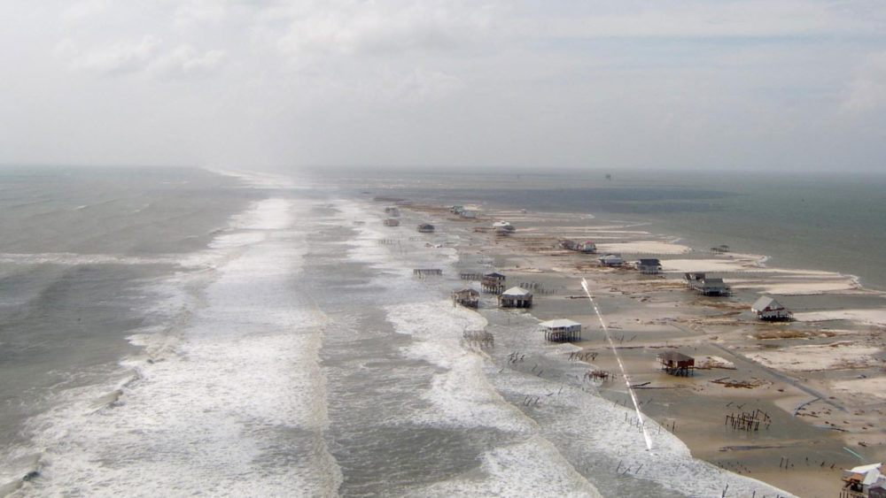
Hurricane Katrina damaged or destroyed 450 of the 500 houses on the west end of Dauphin Island in 2005.
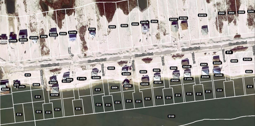
The real estate website Zillow still assigns property values to parcels of land on the west end of Dauphin Island that are now underwater. Zillow
https://e360.yale.edu/features/on-the-alabama-coast-the-unluckiest-island-in-america
On the night of September 12, 1979, a bruising Category 3 hurricane named Frederic roared up the Gulf of Mexico and across Alabama’s Dauphin Island before surging into Mobile Bay. The 120-mile-per-hour winds and 12-foot storm surge toppled the only bridge to the island and destroyed 140 houses. For several years, the only way for workers to commute to nearby Mobile was by ferry.
Travel guides from the era described Dauphin Island as one of the Gulf’s hidden gems, a quaint, unpretentious oasis of pastel bungalows, white sugar-sand beaches, and spectacular sunsets. They didn’t mention hurricanes or the fact that the 14-mile island was slowly sinking into the Gulf of Mexico.
Dauphin is shaped like a drumstick – widest on its east end, where there is a lush maritime forest, a historic Civil War–era fort, and a nationally celebrated bird sanctuary; and pinched on its west end, where it has lost over 100 feet of shoreline to erosion and storms in the last few decades, and vacation houses now perch like birdhouses above the water. It is one of a score of low-lying islands, some no more than sand spits, which dangle like a necklace along the Gulf Coast from Alabama to Louisiana. Once a formidable barrier between the Gulf and the mainland, the islands are now tattered and uneven, some dense with sedge and trees, others ripped asunder by storms and all but vanished beneath the water.
Frederic wasn’t the first hurricane to pummel the Alabama resort, nor would it be the last. For as long as anyone has kept records, Dauphin Island has been a magnet for violent storms. In the early 1900s, five powerful hurricanes lashed the then mostly empty barrier. More recently, a dozen hurricanes and tropical storms have battered the resort, including Camille in 1969, Frederic in 1979, Georges in 1998, Ivan in 2004, and Katrina in 2005. In 2017, Nate, a weak storm with 65-mile-per-hour winds, pushed several feet of water into dozens of homes.
...
Now, with the planet warming, sea levels rising, and oceans heating up, providing more fuel, hurricanes are likely to grow even larger and more destructive in the future, says Kerry Emanuel, one of the leading atmospheric scientists and hurricane experts, based at MIT. By the next century, a Category 5 hurricane – such as Dorian, which devastated the Bahamas this week – could go from being a one-in-800-year storm to a one-in-80-year storm. Unsurprisingly, bigger hurricanes cause more damage, and with more property than ever lining the Atlantic and Gulf coasts, the risk of future epochal storms is only likely to increase.
Much of that damage will be along the heavily developed but low-lying barrier islands of Florida, South Carolina, and North Carolina, where millions of second homes, investment properties and beach houses crowd the coast. But even Mid-Atlantic states are at risk, as Hurricane Sandy showed in 2012, with $72 billion in damage. The Gulf states of Alabama, Mississippi, Louisiana, and Texas are especially vulnerable because of their shallow profiles, heavy rates of erosion, and lack of sand dunes and other natural defenses.
...
Following each big storm, Collier and Dauphin Island homeowners follow a familiar script. First, they plead for disaster aid from the federal government. Then they file claims with the federal flood insurance program. Finally, with tax dollars and insurance payouts in hand, they rebuild in the same dangerous location, assuming it isn’t underwater. That’s what happened after Frederic, and after Georges, Ivan, and Katrina, and is now happening again after Nate.
...
“Dauphin Island, and especially the west end, is a poster child for all of our failed public policies, local, state, and federal,” Crozier said. “Really, it is a case study of schizophrenia. The property owners want to be left alone, except when there is a storm. Then they want the taxpayers to pay for new roads and bridges and sand and [to] help them rebuild.”
...
Dauphin Island received over $2 million in federal disaster aid, including $1,125 to replace the town’s welcome sign, which reads, “The Sunset Capital of Alabama.” FEMA also agreed to pay for a temporary sand dune to protect the remaining beach houses along the sand-starved west end. Environmental groups protested that the dune would encourage owners to rebuild in harm’s way. Nevertheless, FEMA paid over $1 million for a five-foot wall of sand designed to last five years.
The temporary dune washed away in less than two years. FEMA officials then wrote a second check for $4 million for another temporary dune. It, too, washed away.
Hurricane Katrina damaged or destroyed 450 of the 500 houses on the west end of Dauphin Island in 2005.
The real estate website Zillow still assigns property values to parcels of land on the west end of Dauphin Island that are now underwater. Zillow
https://e360.yale.edu/features/on-the-alabama-coast-the-unluckiest-island-in-america
InfoView thread info, including edit history
TrashPut this thread in your Trash Can (My DU » Trash Can)
BookmarkAdd this thread to your Bookmarks (My DU » Bookmarks)
0 replies, 685 views
ShareGet links to this post and/or share on social media
AlertAlert this post for a rule violation
PowersThere are no powers you can use on this post
EditCannot edit other people's posts
ReplyReply to this post
EditCannot edit other people's posts
Rec (2)
ReplyReply to this post