General Discussion
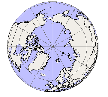
Related: Editorials & Other Articles, Issue Forums, Alliance Forums, Region ForumsWhen the arctic ice cap is gone the mercator orientation will be obsolete
Last edited Sat Sep 1, 2012, 01:23 PM - Edit history (1)
Our standard view of the world as functionally east-west has always made some sense because you couldn't sail over either pole.

Antarctica is a continent and isn't going anywhere, but the arctic is just one vast ocean that happens to have a lot of its area covered by floating ice.
And when the arctic ice cap is gone (or nearly gone) it will make Canada and Russia more convenient shipping partners. New seaports will be developed on the formerly useless northern edges of Europe and North America. Reliance on pipelines for both Russian and Canadian fossil fuels will be reduced, and shipping increased.
It will reorient the world. Currently useless parts of alaska will become someplace from which you can sail to the Netherlands as easily as to the continental US. Unfortunately, the Netherlands will no longer exist, of course, so the trip would be for nothing.
In fact, in a polar-projection world Alaska becomes a very implausible part of the US (though a more valuable one than anyone ever dreamed of.)
For airplanes and missiles we are accustomed to thinking of the world as the globe it is. (Most of our nukes are programmed to fly up over the arctic because that is the shortest way to Russia. Don't tell Sarah Palin, though.)
Soon shipping in the northern hemisphere will follow suit. And as the formerly temperate zones become flooded typhoon preserves in social and economic collapse, the world economy will shift further and further north. Canada will become a major world power.
It is funny to think back over the endless maneuvering by Russia and Germany to gain warm-water ports, and how their inability to control warm-water ports allowed England (smack in the warm path of the gulf stream) to exert naval dominance over Europe.
And those many centuries of the arctic ice pack dictating international affairs will seem a prehistoric curiosity.
 = new reply since forum marked as read
Highlight:
NoneDon't highlight anything
5 newestHighlight 5 most recent replies
= new reply since forum marked as read
Highlight:
NoneDon't highlight anything
5 newestHighlight 5 most recent replies

dawg
(10,624 posts)that the 1 or 2 billion survivors will get to live in.

Junkdrawer
(27,993 posts)One thing is for certain: it won't be the same as the current techno-industrial world (except no polar ice).
I'm thinking small Amish-like communities raided constantly by semi-machine gun wielding nomads. Foreign trade may mean importing goods from other communities a few hundred miles away.

cthulu2016
(10,960 posts)Junkdrawer
(27,993 posts)We have thousands of interdependencies built into our system. When a few of them fail, we can reroute, as it were, and keep going. When too many fail all at once, they collapse.
Oh, and if AGW were JUST a slow even rise in temperature, we'd probably be able to adapt. Alas, it is not.

muriel_volestrangler
(101,321 posts)The ice extent in winter hasn't changed that much. Remember, the "warm water ports" concern of Russia was because places like St. Petersburg, perfectly usable in summer, weren't in winter.
The Arctic is becoming like the Baltic - freezing with seasonal ice in winter, and clearing in summer, rather than having multi-year ice.
As far as the usefulness of the Mercator projection goes - since it's never shown distances accurately, it's always been a bit useless. The only thing is shows properly is compass bearing.
cthulu2016
(10,960 posts)It seems likely that in 50-100 years the remaining seasonal freeze area will be such that the continental coasts will be open year-round with the ice cap limited to a smaller area in the middle of the arctic.
If the straits between the Kara and Laptev seas are open year-round then I think Alaska to Europe would always be an option, though having to sail around the pack.
But I certainly agree with everything you say.

renie408
(9,854 posts)You have to cut me some slack because I am dealing with a foul headache, but isn't there something to...you know...NORTH and SOUTH that would make the logical layout of maps, well, LOGICAL whether there is ice at the top and bottom or not?
cthulu2016
(10,960 posts)Since the earth revolves on its axis the sun does rise generally in the east and set generally in the west so map orientation is not entirely random. There may be that there is a soft bias toward east west as the path the sun (appears to) follow.
And in the northern hemisphere the northernmost star moves the least, being the north star useful for navigation. So again, not random. Though there is nothing intrinsically "up" about north.
But the classic mercator projection that we all grow up with is used primarily because any rectangular plot of the surface of a globe will feature massive distortions and the mercator orientation pushes those distortions off to the parts of the map that are "unimportant" because nobody goes there. And we don't go there because they are frozen places.
If there was anything interesting going on at the north or south pole we couldn't use the mercator projection because those two paces do not (and cannot) even exist on the map.
If, as a thought experiment, most human population was in Greenland and Australia, and most sea trips were between those places, it seems likely that we would have settled on some type of map that did not grossly distort those places and most accurately represented the distance between them, and their distance to other places.
Even if such a map didn't follow our sense of how the sun moves we would adopt it because it would be the most "right" for everything we used it for.
And in an alternate history where the Arctic ocean was ice-free and Russia and Canada had been the two great nations of the world it seems likely that the north polar projection view in the OP would be a lot more popular.