General Discussion
Related: Editorials & Other Articles, Issue Forums, Alliance Forums, Region ForumsBREAKING: Tropical Storm Elsa Forms: Florida, Caribbean Should Track Forecast Closely
Watching for ya malaise! 
Tropical Storm Elsa has formed in the Atlantic Ocean and is expected to barrel toward the Caribbean by Friday, where warnings have been issued for the Windward and Leeward Islands. Residents of the Caribbean and Florida should track the progress of Elsa closely through the holiday weekend.
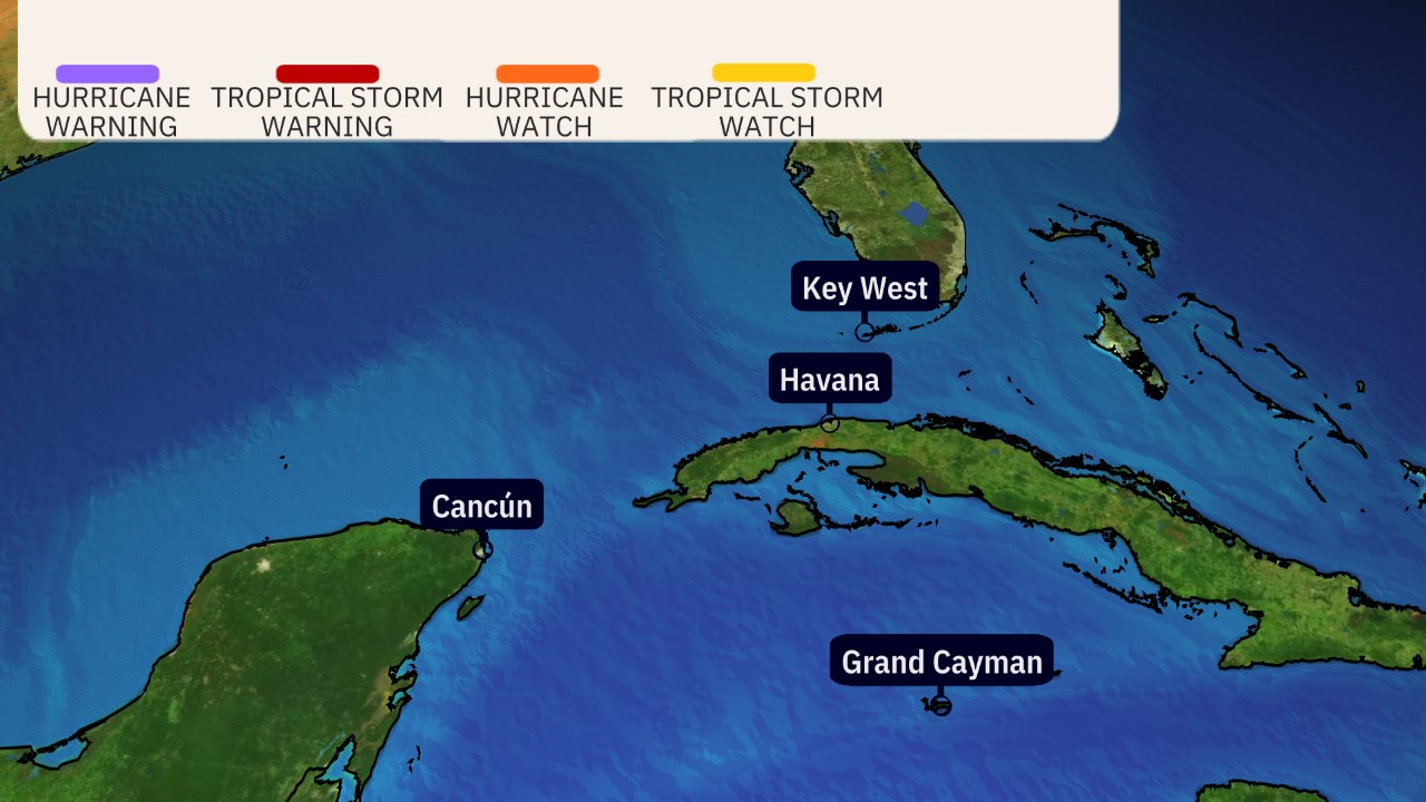
The National Hurricane Center (NHC) said Elsa was centered more than 800 miles east of the Windward Islands as of early Thursday. Tropical storm warnings have been issued for parts of the Windward and Leeward Islands, where tropical storm force conditions (winds of at least 39 mph) are expected on Friday. Those areas are shown in red on the map below.
Any tropical storm watches in effect are shown in yellow in the map below, meaning tropical storm conditions are possible in these areas on Friday.
Elsa is tracking quickly westward at 25 mph. That should allow it to arrive in the Windward and southern Leeward Islands by Friday as a strong tropical storm. The NHC says rainfall totals of 3 to 6 inches with isolated totals up to 8 inches are possible in the Windward and southern Leeward Islands Friday. This could lead to isolated flash flooding and mudslides. That said, the system's fast forward speed will limit the heavy rain threat that might otherwise be greater.
More: https://weather.com/storms/hurricane/news/2021-07-01-tropical-storm-elsa-forecast-caribbean-united-states
 = new reply since forum marked as read
Highlight:
NoneDon't highlight anything
5 newestHighlight 5 most recent replies
= new reply since forum marked as read
Highlight:
NoneDon't highlight anything
5 newestHighlight 5 most recent replies

malaise
(269,200 posts)It's a tropical storm - the better news - it's moving real fast.
Florida doesn't need a tropical storm.

BumRushDaShow
(129,608 posts)Accuweather said that this is the earliest-forming "E" storm, breaking last year's record of Edouard by 5 days.
And yeah, since this is rainy season in FL, this is definitely not needed for the recovery efforts in Miami. 
malaise
(269,200 posts)We're all watching in the Caribbean - we can't fathom how this is so early. Storms at this time of the season usually form in the Eastern Pacific or the Northern Caribbean and Gulf of Mexico. The water is too hot - it's that simple.
https://www.nhc.noaa.gov/graphics_at5.shtml?start#contents
It's moving at 25mph so it's won't stick around and flood us out
https://www.nhc.noaa.gov/storm_graphics/AT05/refresh/AL052021_5day_cone_no_line_and_wind+png/085512_5day_cone_no_line_and_wind.png
BumRushDaShow
(129,608 posts)The hot water is a concern for rapid intensification but then the water temps would probably be worse later in the season too.
I read yesterday where the "coldest inhabited" place on earth (in Siberia) had a record high of 88F over the weekend (normal summer highs there are in the 60Fs). Of course the 121F record in British Columbia is just awful.

superpatriotman
(6,252 posts)It’s been a very wet June here. The ground is saturated.