General Discussion
Related: Editorials & Other Articles, Issue Forums, Alliance Forums, Region ForumsExperts say Ida will make landfall as a Cat 3 Hurricane - get out of her way
If Ida hits New Orleans on Sunday, it will be exactly 16 years to the day that Katrina devastated the same area.

Tropical Storm Ida Advisory Number 4
NWS National Hurricane Center Miami FL AL092021
500 AM EDT Fri Aug 27 2021
...IDA STRENGTHENS AS THE CENTER PASSES THROUGH THE CAYMAN
ISLANDS...
...AIR FORCE RESERVE AND NOAA HURRICANE HUNTER AIRCRAFT ENROUTE TO
INVESTIGATE THE STORM...
SUMMARY OF 500 AM EDT...0900 UTC...INFORMATION
----------------------------------------------
LOCATION...20.0N 81.4W
ABOUT 50 MI...80 KM NNW OF GRAND CAYMAN
ABOUT 145 MI...230 KM SE OF THE ISLE OF YOUTH
MAXIMUM SUSTAINED WINDS...45 MPH...75 KM/H
PRESENT MOVEMENT...NW OR 320 DEGREES AT 15 MPH...24 KM/H
MINIMUM CENTRAL PRESSURE...1001 MB...29.56 INCHES
WATCHES AND WARNINGS
--------------------
CHANGES WITH THIS ADVISORY:
None.
SUMMARY OF WATCHES AND WARNINGS IN EFFECT:
A Storm Surge Watch is in effect for...
* Sabine Pass to Alabama/Florida border
* Vermilion Bay, Lake Borgne, Lake Pontchartrain, Lake Maurepas, and
Mobile Bay
A Hurricane Watch is in effect for...
* Cameron, Louisiana to the Mississippi/Alabama border
* Lake Pontchartrain, Lake Maurepas, and Metropolitan New Orleans
A Tropical Storm Warning is in effect for...
* Cayman Islands
* Cuban provinces of Matanzas, Mayabeque, Havana, Artemisa, Pinar
del Rio, and the Isle of Youth
A Tropical Storm Watch is in effect for...
* Mississippi/Alabama border to the Alabama/Florida border.
A Storm Surge Watch means there is a possibility of life-
threatening inundation, from rising water moving inland from the
coastline, in the indicated locations during the next 48 hours.
For a depiction of areas at risk, please see the National Weather
Service Storm Surge Watch/Warning Graphic, available at
hurricanes.gov.
A Hurricane Watch means that hurricane conditions are possible
within the watch area. A watch is typically issued 48 hours
before the anticipated first occurrence of tropical-storm-force
winds, conditions that make outside preparations difficult or
dangerous.
A Tropical Storm Warning means that tropical storm conditions are
expected somewhere within the warning area within 36 hours.
A Tropical Storm Watch means that tropical storm conditions are
possible within the watch area, generally within 48 hours.
Interests elsewhere in central and western Cuba, in the northern
Yucatan Peninsula, and elsewhere along the northern U.S. Gulf coast
should monitor the progress of this system. Hurricane warnings
will likely be required for portions of the northern Gulf coast
later today. Interests in the Dry Tortugas should also monitor the
progress of Ida.
 = new reply since forum marked as read
Highlight:
NoneDon't highlight anything
5 newestHighlight 5 most recent replies
= new reply since forum marked as read
Highlight:
NoneDon't highlight anything
5 newestHighlight 5 most recent replies

Lovie777
(12,329 posts)In contact with my relatives in New Orleans.

Croney
(4,670 posts)if they get hurt in the hurricane, there are absolutely no hospital beds due to Covid. Such a nightmare scenario.

brer cat
(24,606 posts)I hope they all stay safe.

SheltieLover
(57,073 posts)

babylonsister
(171,092 posts)over the warm waters of the gulf. Scary. I'd be packing my car now. 

Amishman
(5,559 posts)It was intensifying with half of the circulation over land, can't recall seeing anything like it.
Cloud tops warmed in the past hour, but the structure is still well intact. Won't take long to resume strengthening.
This looks scary.
wnylib
(21,611 posts)
LeftInTX
(25,555 posts)It's supposed to intensify Saturday night. It's moving at 16 MPH
I don't like WHERE it is going to be 947 mb...Usually the lowest is several hundred miles offshore...That part is scary....However, Katrina's low was 902 mb..
Latest NHC..Maximum--NOLA is about 29.5N.. For comparison Corpus Christi is about 28.6 N
FORECAST VALID 29/1800Z 28.6N 90.5W
MAX WIND 120 KT...GUSTS 145 KT.
64 KT... 35NE 30SE 20SW 30NW.
50 KT... 60NE 60SE 30SW 50NW.
34 KT...130NE 110SE 80SW 110NW.
Intensity models are a few hours behind...It's almost 12 Z
t got his masters and PhD in Florida..)
YIKES -This one scares me!


https://www.nhc.noaa.gov/text/refresh/MIATCDAT4+shtml/280859.shtml
NHC says storm surge of 10-15 ft, Katrina had 30.....Katrina spent more time over water, but who knows...
https://www.wunderground.com/hurricane/atlantic/2021/hurricane-ida
wnylib
(21,611 posts)to follow the details given by the weather services and I have never lived in hurricane regions to learn warning signs. I can just follow the images of the trajectory and listen to assessments of the strength of a hurricane.
The latest that I have heard in predictions is that it is headed for Louisiana and Mississippi and is expected to reach cat 4 strength. Katrina wasa cat 5 at one point, but weakened to a 3 by landfall.
I know that other factors besides wind strength influence the amount of damage. A slow moving one can do more flood damage in addition to the surge.
Up north, we experience some of the rain and flood damage of hurricanes if they move slowly up the Atlantic coast. In the early 1970s, there was a hurricane, whose name I don't remember, that was devaststing to Pennsylvania, where I lived at the time.
But Gulf hurricanes usually don't affect the Mid Atlantic and New England states.

rampartc
(5,435 posts)have plenty of food and water.
i would rather die in my own home than on the road. will check in when the power comes back on.( maybe december like last time)

malaise
(269,160 posts)to buy eggs and pack them in containers with salt- they will last forever.
Rain associated with Ida is till falling here in Jamaica
Shanti Shanti Shanti
(12,047 posts)malaise
(269,160 posts)

Shanti Shanti Shanti
(12,047 posts)They don't know yet, it hasn't even cleared Cuba, wait till it reforms over gulf
Response to Shanti Shanti Shanti (Reply #11)
malaise This message was self-deleted by its author.
malaise
(269,160 posts)Shanti Shanti Shanti
(12,047 posts)From Eastern TX to Miss. gulf coast or maybe FL panhandle still possible
malaise
(269,160 posts)Pressure is dropping precipitously and there is rapid intensity - from 45nph to 60mph in less than three hours.
Shanti Shanti Shanti
(12,047 posts)
BumRushDaShow
(129,479 posts)Link to tweet
TEXT
@NHC_Atlantic
Storm Surge, hurricane, and tropical storm watches are in effect for portions of the Louisiana, Mississippi, and Alabama coasts. Follow @NWSNewOrleans, @NWSLakeCharles, and @NWSMobile for local information in those areas.
http://hurricanes.gov/#Ida
Image
Image
11:12 AM · Aug 27, 2021
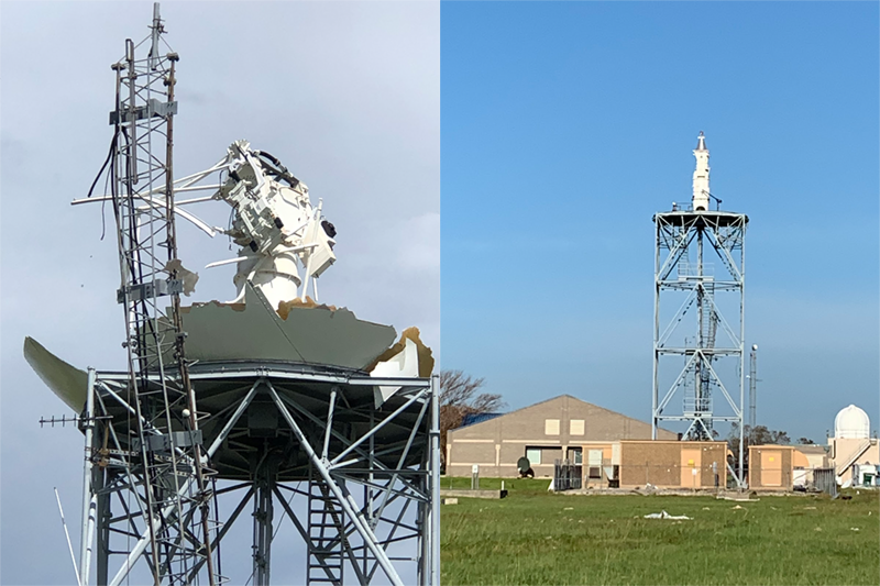
Lake Charles finally got their doppler array repaired and back on line this past January after it was destroyed by Hurricane Laura, literally a year ago today (August 27, 2020).
https://www.weather.gov/news/012221-lake-charles-radar

Shanti Shanti Shanti
(12,047 posts)the worst winds around the core I mean, yeah everybody on the gulf coast needs to be watching.
I'm 5 mi from the beach, surge wont affect me here, topped off the cars, got more gen gas, just to safe.
Grocery shopping too, mandatory for everybody to wear a mask, yay
LeftInTX
(25,555 posts)Shanti Shanti Shanti
(12,047 posts)LeftInTX
(25,555 posts)It hasn't been a possible Texas storm since it became a Tropical Depression....
Once it became a TD, models quickly converged on the path...
When it was just a blob of low pressure, counter pressure etc wasn't showing a path...Once the pressure got a bit lower, steering layers became more apparent

bearsfootball516
(6,377 posts)hatrack
(59,592 posts)000
WTNT34 KNHC 271155
TCPAT4
BULLETIN
Tropical Storm Ida Intermediate Advisory Number 4A
NWS National Hurricane Center Miami FL AL092021
800 AM EDT Fri Aug 27 2021
...AIR FORCE AND NOAA AIRCRAFT FIND IDA STRENGTHENING OVER THE
NORTHWEST CARIBBEAN SEA...
SUMMARY OF 800 AM EDT...1200 UTC...INFORMATION
----------------------------------------------
LOCATION...20.3N 81.7W
ABOUT 75 MI...125 KM NNW OF GRAND CAYMAN
ABOUT 115 MI...185 KM SE OF THE ISLE OF YOUTH
MAXIMUM SUSTAINED WINDS...60 MPH...95 KM/H
PRESENT MOVEMENT...NW OR 320 DEGREES AT 15 MPH...24 KM/H
MINIMUM CENTRAL PRESSURE...996 MB...29.41 INCHES
EDIT
https://www.nhc.noaa.gov/text/refresh/MIATCPAT4+shtml/271155.shtml?
malaise
(269,160 posts)This one is trouble
hatrack
(59,592 posts)Pressure unchanged.

Liberal In Texas
(13,576 posts)NewHendoLib
(60,021 posts)that the strengthening is often greater than the forecasts, though once land approaches, they weaken a bit. Nothing would surprise me as to what this storm does between now and landfall - mother nature is pretty pissed at us right now.

Whiskeytide
(4,463 posts)… forecasts. Over the last few years, I’ve been consistently correct, unfortunately.

GB_RN
(2,382 posts)Yeah, I'd say so, since we've fucked the place pretty royally. In the movie "The Matrix", Agent Smith calls humans "a virus" on the planet (and that the machines are "the cure" . It's thought that I'd had a few times before that and more than a few times since. It's not all that far from the truth, as we are killing our host.
NewHendoLib
(60,021 posts)Moebym
(989 posts)But what does the M stand for on these maps?
EDIT: Never mind, I found out that it means "Major Hurricane".
GB_RN
(2,382 posts)😉🤣😂🤣
MoonRiver
(36,926 posts)
BumRushDaShow
(129,479 posts)The peak of hurricane season is about underway.
Ida's path may shunt rain/moisture up here to Philly as a front moves east next week (along with potential remnants of itself depending on how things line up), and between Fred and Henri, I've already had almost 9" of rain for the month of August.
malaise
(269,160 posts)It's still raining here two days later - it stopped for a while yesterday but returned from about 7.00pm last night and has not stopped since.

BumRushDaShow
(129,479 posts)Our flash flood guidance values are low because many (although not all) have had excessive rain the past couple weeks. We are already under a flash flood watch for possible slow-moving rain-making pop-ups with a frontal move over the area.
Link to tweet
TEXT
NWS Mount Holly
@NWS_MountHolly
·
Aug 27, 2021
One last day of hot & humid weather for the region. A Heat Advisory remains in effect for Heat Index values around 100°. Although humidity levels remain elevated on Saturday, temperatures will be much cooler. Remember to stay cool and hydrated! #NJwx #PAwx #DEwx #MDwx
Image
Image
NWS Mount Holly
@NWS_MountHolly
Showers & thunderstorms will develop this afternoon & tonight. Although damaging winds are possible, our main concern is for heavy rain which could lead to flash flooding. A Flash Flood Watch is in effect through Saturday. Be aware for Flash Flood Warnings!
Image
Image
5:02 AM · Aug 27, 2021
With the high dewpoints the past couple days (the dewpoint was reported as being 79 in Atlantic City an hour ago with an air temp of 80
 ), the whole area around SE PA and South Jersey is having some Jamaica weather. My potted plumeria, hibiscus, and stephanotis are loving it though.
malaise
(269,160 posts)Reports are just coming in
BumRushDaShow
(129,479 posts)just raining all over Cuba and the Caymans too. 

(took me a bit to even find Jamaica under all of that)

KY_EnviroGuy
(14,494 posts)that may be as dangerous as initial storm winds and could conceivable even affect the Ohio Valley, depending on tracking.
This is a potential major disaster from more strain on medical emergency facilities (many of which are currently overloaded from COVID) as well as extreme demands on police, fire and rescue teams.
Let's hope FEMA, Red Cross and National Guard groups are already gearing up for this one. I'm sure our President is putting the Federal gears in motion.
I predict now matter how well we do as a nation in response, Republicans will turn this into anther reason to criticize Democrats and the Biden Administration.
KY
malaise
(269,160 posts)Serious issues here

But it will be a chance for Biden to show how a REAL President reacts to a disaster. Note: he won't be strumming a guitar at a friend's birthday party.....

marmar
(77,091 posts)malaise
(269,160 posts)Missed two TSs in a week
Marius25
(3,213 posts)Pressure at 990.6 right now. Current intensity prediction is 120 mph Cat 3 at landfall, but very well could be a Cat 4 at landfall. Really nothing stopping it from intensifying quickly.
malaise
(269,160 posts)We're almost there - Gilbert, Andrew, Katrina, Rita etc., etc.
It was 45mph at 5.00am - it's now 65mph and was 6-mph at 7.58am.
Get out of Ida's way folks.

Solly Mack
(90,787 posts)More than a little dread here. Remembering Hurricane Laura this time last year.
malaise
(269,160 posts)Damn! You don't need this.
Solly Mack
(90,787 posts)Got everything for my fur-babies prepared. They are my primary concern.
I'll duck and cover with them come time. (If Ida takes the Cameron, Lake Charles route - if not, I'll probably keep watch while they remain tucked away and then take cover in the event Ida spawns tornadoes.)
Yard is clear, trash cans tucked away, big windows covered, smaller ones taped.
If Ida takes the New Orleans route, we will still get high winds but not as bad. Still...flooding, power outages.
And all those people on ventilators all over the state. 
malaise
(269,160 posts)You are ready as always. This doesn't look good
Solly Mack
(90,787 posts)
Grammy23
(5,813 posts)We hope and prepare. We never just leave it to chance. So have some optimism that it will be okay but prep anyway.
Solly Mack
(90,787 posts)Also coming the anniversary of Katrina - lot of minds here fixed on those two events, so we're all scurrying about getting things ready.
Now if only they put as much effort into masking and vaccines.
Pandemic meets Hurricane part 2...the horror continues.
But hopefully...
Grammy23
(5,813 posts)Ask me if we are dropping our guard. Not on your life. A slight wobble to the East (and that could happen) and we’ll be battening down the hatches. I’ve been dealing with storms like this for my entire life. Even when we didn’t live on the Gulf Coast, my parents had property and a boat on the coast that had to be cared for. I’ve lived somewhere along the Gulf Coast since 1965 so starting with Hurricane Betsy, I’ve learned to never assume you are out of the woods until the storm is inland and dissipated.
We checked our storm stash of food two days ago. We’ll gas up and get a few groceries (eggs) if it turns a little bit more to the East of its projected path. We have a generator and propane to run it. So we’re ready, no matter where Ida goes. Please think of the folks in her path. It is a disaster you almost can’t believe until you are part of it. Consider a donation to the organizations that help after a disaster. Many along the Gulf Coast will need help.

malaise
(269,160 posts) Grammy23
(5,813 posts)I know how serious you take these storms. Just wanted you to know you have company. These storms can cause unimaginable damage and trauma. Going through a bad storm gives you perspective like nothing else. Living without your normal life is stressful and having no certainty when your power will be restored, the water has good water pressure and is safe to drink will wear down the strongest person. Major storm damage takes the pressure up many notches. The more advance prep you can do (food, water, alternative power sources) the better off you’ll be. I know some people think we are too hyper-vigilant but having been through several cat 3 and above storms will make you pay attention to any storm that can potentially come near you!
Thanks for your efforts to keep DUers aware of storms. As a group, we can raise a good bit of help to disaster organizations. We’re all in this together whether we are in the eye of the hurricane or just monitoring from afar.
malaise
(269,160 posts)and yes we're all in this together
Here's Ida

ancianita
(36,137 posts)Nothing much, but battening down and packing up the car to leave tomorrow is what I'd be doing if I were near the north Gulf.
Can't wait 'til October.
malaise
(269,160 posts) ancianita
(36,137 posts) Solly Mack
(90,787 posts)
spanone
(135,877 posts) malaise
(269,160 posts)It strengthened from 45mph to 75mph between 5.00am and the last update
roamer65
(36,747 posts)malaise
(269,160 posts)This is not good
roamer65
(36,747 posts)We humans somehow seem to think we exempt from the natural order.
But…we all eventually learn otherwise.
You watch it with that storm brewing out east of you in the Atlantic.

malaise
(269,160 posts)or we will be selected Watching carefully.
ancianita
(36,137 posts) Response to malaise (Original post)
SYFROYH This message was self-deleted by its author.

SYFROYH
(34,183 posts)(alt version)
(snoop version)
(ray manzarek talking about ROTS)
(infected mushroom version)
(stavros lantsias version)
(david reguiero organ trio version)
(spring quintet version)
malaise
(269,160 posts)Thanks for the original and the covers
Hoosier
(247 posts)These are all awesome
THANKS
Cheezoholic
(2,033 posts)Its looking more and more that torrential rainfall could move right over areas in E TN and W NC that were devastated by deadly flash flooding last week. Potential for upwards of 10 inches or more.
malaise
(269,160 posts)What a mess
LeftInTX
(25,555 posts)Even a tropical storm can create inland flooding.....

TrollBuster9090
(5,955 posts)storm surge that was the problem.
malaise
(269,160 posts)This is a serious video
Heard a while ago that one good thing this time around is that the Mississippi is very low right now and so far Ida is moving at 15mph
Shanti Shanti Shanti
(12,047 posts)malaise
(269,160 posts)Bookmarking
Shanti Shanti Shanti
(12,047 posts)I talked to him on live twitter a few times, lol, my name was up in lights on the screen, he covers all the hurricanes, with local area news sources too
malaise
(269,160 posts)Ida reminds me of Maria in terms of the rapid strengthening before it destroyed Dominica and devastated some of the Leeward islands, the Virgin islands and Puerto Rico. Moved from 35mph yesterday to 45mph this morning - it is now 80mph and is yet to reach the very warm water in the Gulf of Mexico
Looks like landfall will be West of NOLA
ancianita
(36,137 posts)a lot of water on NOLA
Shanti Shanti Shanti
(12,047 posts)malaise
(269,160 posts)Maria peaked at 175mph but hit Puerto Rico as a Cat 4
https://en.wikipedia.org/wiki/Hurricane_Maria
Shanti Shanti Shanti
(12,047 posts)
tclambert
(11,087 posts)You have the absolute right to drown in order to prove to the tyrannical government that your personal freedom means more than life itself.
Moebym
(989 posts)
dixiegrrrrl
(60,010 posts)I'm remembering the horrific tragedy of the hospital that got flooded and the still disputed decisions the staff had to make concerning bed ridden patients.
The states in the danger zone are also completely deluged with their own virus patients...where are evacuated patients supposed to go?
I never in my gut believed in true evil, until trump managed to make a pandemic into a full blown plague solely out of greed to profit from it.
Meanwhile, wishing for best of luck to my fellow DU folks in the target zones.
malaise
(269,160 posts)I don't think NOLA will get the worst of Ida.
Hope it stays away from you sis grouphug:

kentuck
(111,110 posts)A lot of rain.
malaise
(269,160 posts)We had Ida related rain from Wednesday.
The Mississippi River is very low right now but I read that it needs rain from northern Minnesota.
kentuck
(111,110 posts)Stay safe.
malaise
(269,160 posts)now we look east to see what else is coming

kentuck
(111,110 posts)But being good doesn't hurt, either. 