General Discussion
Related: Editorials & Other Articles, Issue Forums, Alliance Forums, Region Forums1776 map of Manhattan vs evacuation zones...eerie
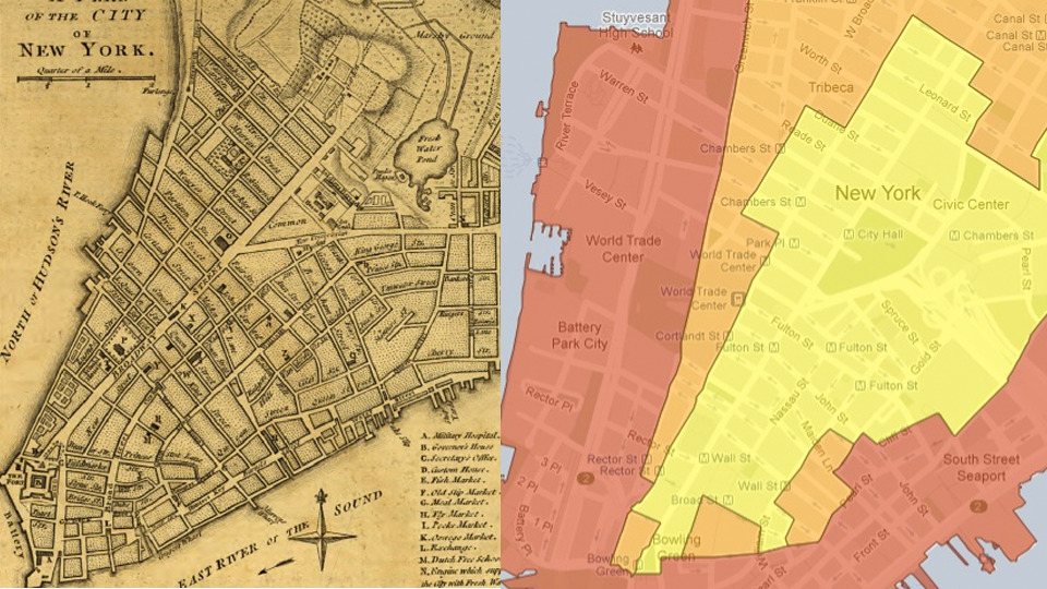
Manhattan’s Sandy Evacuation Zones Match Up With the Island’s Original Coastline
By Leslie Horn
Look at the http://updates.gizmodo.com/post/34784175229/manhattans-sandy-evacuation-zones-match-up-with
two maps above. On the left is Manhattan in 1776. On the right is the Hurricane Sandy evacuation map. If your apartment’s in Zone A in 2012, it would’ve been in the ocean in 1776, before the island was built up by landfill.
On the evac guide, red is Zone A, or the lowest lying area with the highest flood risk—in fact much of it is still under water. Greenwich Street, the eastern line of Zone A is on the edge of the Hudson River. ManhattanPast explains the correlation:
The eastern line of Zone A along the Hudson River runs along Greenwich Street, which was at the waterfront in 1776. The old slips on the East River extend inland to Queen Street, now Pearl Street, which is near where Zone A runs along the East River. Also notable on the 1776 map is Bayard’s Mount, the high land rising in the area marked “Marshy Ground” north and northwest of the old Collect Pond. The pond was drained in the early 19th Century and Bayard’s Mount was leveled to fill it in, but as can be seen in the evacuation plan, the pond and the marsh left their mark on modern Manhattan in the form of a hook-shaped low area delineated by the border of Zone B.
I guess once a flood zone, always a flood zone. [ManhattanPast]
h/t Adam Rogers, Tim DeChant
 = new reply since forum marked as read
Highlight:
NoneDon't highlight anything
5 newestHighlight 5 most recent replies
= new reply since forum marked as read
Highlight:
NoneDon't highlight anything
5 newestHighlight 5 most recent replies
Whisp
(24,096 posts)
barnabas63
(1,214 posts)No, I disagree. It was not a "flood zone" until global warming. Building up the land worked pretty well for most of our nation's history. If we'd gotten our act together in the 1960s and 1970s it would still be working well. But because everyone laughed at Carter's efforts to change our energy habits this is where we are today.

Old and In the Way
(37,540 posts)Had we followed Carter's lead on energy policy, we'd have true energy independence and no need for a $700BB Defense budget that provides muscle for Big Oil and their business plan that makes us dependent on mid-east oil. A shame most Americans can't connect the dots.
barnabas63
(1,214 posts)As a kid in the 1970s, I remember our public school textbooks (grades 4 and 5!) talked about BIG problems in the future if we didn't get pollution under control. Reading about it back then scared the bejezzus out of me, but I thought that surely the adults would take care of things, because they knew of the potential crisis.
Guess I was wrong....

a la izquierda
(11,797 posts)I remember reading about melting ice caps, and freaking out because I lived at the Jersey Shore. I thought one day the seas would just rise and kill us all.
I didn't realize the scarier fact was that people would watch this slowly happen, yet do nothing.
barnabas63
(1,214 posts)a la izquierda
(11,797 posts)
BumRushDaShow
(129,458 posts)here in Philly that we would be the ocean front and Western Jersey would be the beach, with Jersey's current coast completely under water. I.e., this was because the whole east coast was "sinking". 
Seems it's slowly happening!
I also remember being told that the west coast of the U.S. (notably California) was "growing" and that their beaches would get bigger and bigger and would be further and further away from where they are now.
Bluenorthwest
(45,319 posts)as well. Disaster is when that which works 'pretty well most of the time' fails. This is at least the third failure of those reclaimed areas, not the first.
http://www.nyc.gov/html/oem/html/hazards/storms_hurricanehistory.shtml

cbdo2007
(9,213 posts)
waddirum
(979 posts)Even high rises like the John Hancock tower were built on land that used to be lake marsh.

PoliticAverse
(26,366 posts)It flooded in 1821, predating any 'global warming'.
"The hurricane produced a storm surge of 13 feet (4 m) in only one hour at Battery Park. Manhattan Island was completely flooded to Canal Street; one hurricane researcher remarked that the storm surge flooding would have been much worse, had the hurricane not struck at low tide."
http://en.wikipedia.org/wiki/1821_Norfolk_and_Long_Island_hurricane
http://www.nyc.gov/html/oem/html/hazards/storms_hurricanehistory.shtml
barnabas63
(1,214 posts)When the storm hit, they said the record storm surge at Battery Park was about 10 feet??
PoliticAverse
(26,366 posts)slackmaster
(60,567 posts)So it takes less of a surge to do a given amount of flooding.
PoliticAverse
(26,366 posts)
barnabas63
(1,214 posts)I appreciate learning something new...

cprise
(8,445 posts)You can count on that.


malaise
(269,157 posts)It is time he is vindicated publicly
RoccoR5955
(12,471 posts)They built up a lot of the wetlands, and other areas, and started building on it. The Hudson is not as big, or swift as the Mississippi, nor is NY below sea level, so there are not the levees that there are in New Orleans.
Go and look at maps of Brooklyn, Queens and Long Island from 200 or more years ago, heck, go back 100 years ago, and you will find that a lot of streets that are there now, were swamps and such.
Did you know that what is now the Metro North Railroad, running out of Grand Central was once above ground? The railroad is actually at ground level. Buildings and streets all along Park Avenue are all above ground level, as the railroad runs underneath.
You can find these old maps on the net, in many places. Just remember that Google is your friend here.
BumRushDaShow
(129,458 posts)I know they did that in alot of cities including here in Philly where they added landfill to expand out into the Delaware River. But those spots always flood woth heavy rains.
slackmaster
(60,567 posts)