Welcome to DU!
The truly grassroots left-of-center political community where regular people, not algorithms, drive the discussions and set the standards.
Join the community:
Create a free account
Support DU (and get rid of ads!):
Become a Star Member
Latest Breaking News
General Discussion
The DU Lounge
All Forums
Issue Forums
Culture Forums
Alliance Forums
Region Forums
Support Forums
Help & Search
General Discussion
Related: Editorials & Other Articles, Issue Forums, Alliance Forums, Region ForumsThere Are Giant Camera Resolution Test Charts Scattered Across the US
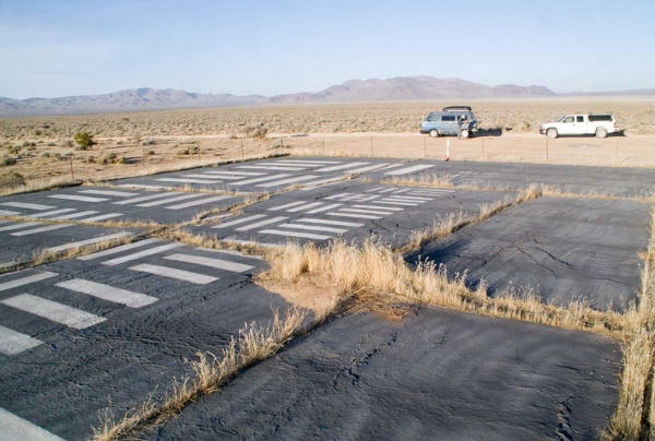
When people test cameras and lenses for resolution, they commonly use special resolution test charts that are filled with black bars of varying lengths and thicknesses. They’re kind of like eye charts, except for cameras instead of eyeballs, and with lines instead of letters.
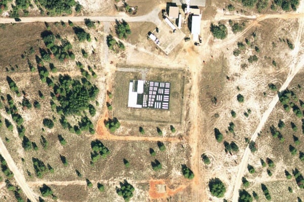
Well, did you know that in dozens of locations around the United States, there are gigantic resolution test charts on the ground?
The Center for Land Use Interpretation writes that the strange “land-based two-dimensional optical artifacts” are used for the development of aerial photography — cameras built into airplanes and drones.
The resolution charts were mostly used during the 50s and 60s, but some of them may still be used nowadays to calibrate “flying cameras.” They have dimensions of around 50-80 feet and are coated in heavy black and white paint. Here’s what one target looks like from the ground:
more
http://www.petapixel.com/2013/02/15/there-are-giant-camera-resolution-test-charts-scattered-across-the-us/
InfoView thread info, including edit history
TrashPut this thread in your Trash Can (My DU » Trash Can)
BookmarkAdd this thread to your Bookmarks (My DU » Bookmarks)
5 replies, 1529 views
ShareGet links to this post and/or share on social media
AlertAlert this post for a rule violation
PowersThere are no powers you can use on this post
EditCannot edit other people's posts
ReplyReply to this post
EditCannot edit other people's posts
Rec (11)
ReplyReply to this post
5 replies
 = new reply since forum marked as read
Highlight:
NoneDon't highlight anything
5 newestHighlight 5 most recent replies
= new reply since forum marked as read
Highlight:
NoneDon't highlight anything
5 newestHighlight 5 most recent replies
= new reply since forum marked as read
Highlight:
NoneDon't highlight anything
5 newestHighlight 5 most recent replies
There Are Giant Camera Resolution Test Charts Scattered Across the US (Original Post)
n2doc
Feb 2013
OP

Angry Dragon
(36,693 posts)1. Alien landing instructions

Princess Turandot
(4,787 posts)2. Here's the second one in your post..
in Google Maps: http://goo.gl/maps/tE6hJ It's about 50' by 75' in size.

Robb
(39,665 posts)3. USDA aerial maps from the 50s are fascinating historical documents
...created, every one, from aerial photographs -- equally fascinating, those. 

surrealAmerican
(11,361 posts)4. k & r

Champion Jack
(5,378 posts)5. K&R