General Discussion
Related: Editorials & Other Articles, Issue Forums, Alliance Forums, Region ForumsSo now we have to worry about something called a Derecho...
I have never heard this term until today. Apparently, it is a sustained wind out front of a line of thunderstorms.
All day long they have been warning us of a night full of storms and this Derecho.
Anyway, I got something more to worry about now with this elevated weather event.
 = new reply since forum marked as read
Highlight:
NoneDon't highlight anything
5 newestHighlight 5 most recent replies
= new reply since forum marked as read
Highlight:
NoneDon't highlight anything
5 newestHighlight 5 most recent replies

CaliforniaPeggy
(149,640 posts)I would try to be informed about what it might mean to my environment, and plan accordingly.
Like, more cheese on that pizza...


malaise
(269,054 posts)Seriously

Kath1
(4,309 posts)A derecho tore through my area of MD last year and did a lot of destruction. Brought down a lot of trees and power lines. We were without electricity for 8 days. Took a long time time to clean up all the debris. Hope you don't get one.

freshwest
(53,661 posts)Is that what happened near you?
I'm not sure if all parts of the country call these by the same name. Here's a picture and some details. I don't know if we've had them or not:
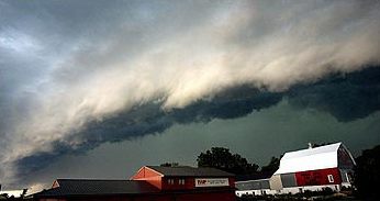
A shelf cloud along the leading edge of a derecho photographed in Minnesota
derecho (/dəˈreɪtʃoʊ/, də-reh-choh, from Spanish: derecho [deˈɾetʃo], "straight" is a widespread, long-lived, straight-line wind storm that is associated with a fast-moving band of severe thunderstorms. Generally, derechos are convection-induced and take on a bow echo (backward "C" form of squall line, forming in an area of wind divergence in the upper levels of the troposphere, within a region of low-level warm air advection and rich low-level moisture. They travel quickly in the direction of movement of their associated storms, similar to an outflow boundary (gust front), except that the wind is sustained and increases in strength behind the front, generally exceeding hurricane-force. A warm-weather phenomenon, derechos occur mostly in summer, especially during June and July in the Northern Hemisphere, within areas of moderately strong instability and moderately strong vertical wind shear. They may occur at any time of the year and occur as frequently at night as during the daylight hours.

Organized areas of thunderstorm activity reinforce pre-existing frontal zones, and can outrun cold fronts. The resultant mesoscale convective system (MCS) forms at the point of the best upper level divergence in the wind pattern in the area of best low level inflow.[3] The convection then moves east and toward the equator into the warm sector, parallel to low-level thickness lines with the mean tropospheric flow. When the convection is strong linear or curved, the MCS is called a squall line, with the feature placed at the leading edge of the significant wind shift and pressure rise.[4]
Derechos are squall lines that are bow- or spearhead-shaped on radar and, thus, also are called bow echoes or spearhead radar echoes. Squall lines typically bow out due to the formation of a mesoscale high pressure system which forms within the stratiform rain area behind the initial line. This high pressure area is formed due to strong descending motion behind the squall line, and could come in the form of a downburst.[5] The size of the bow may vary, and the storms associated with the bow may die and redevelop.
During the cold season within the Northern Hemisphere, derechos generally develop within a pattern of southwesterly winds at mid levels of the troposphere in an environment of low to moderate atmospheric instability (caused by heat and moisture near ground level or cooler air moving in aloft and measured by convective available potential energy) and high values of vertical wind shear (20 m/s (45 mph) within the lowest 5 kilometres (16,000 ft) of the atmosphere). Warm season derechos in the Northern Hemisphere form in west to northwesterly flow at mid levels of the troposphere with moderate to high levels of instability. Derechos form within environments of low-level warm air advection and significant low-level moisture.[6]
Its common definition is a thunderstorm complex that produces a damaging wind swath of at least 250 miles (400 km),[7] featuring a concentrated area of convectively-induced wind gusts exceeding 50 knots (58 mph; 93 km/h).[8] According to the National Weather Service criterion, a derecho is classified as a band of storms that have winds of at least 50 knots (93 km/h; 58 mph) along the entire span of the storm front, maintained over a time span of at least six hours. Some studies add a requirement that no more than two or three hours separate any two successive wind reports.[9] Derechos typically possess a high or rapidly increasing forward speed. They have a distinctive appearance on radar (known as a bow echo) with several unique features, such as the rear inflow notch and bookend vortices, and usually they manifest two or more downbursts.
A typical multi-bow serial derecho
A typical progressive derecho
There are three types of derechos:
* Serial derecho — This type of derecho is usually associated with a very deep low.
* Single-bow — A very large bow echo around or upwards of 250 miles (400 km) long. This type of serial derecho is less common than the multi-bow kind. An example of a single-bow serial derecho is the derecho that occurred in association with the October 2010 North American storm complex.
* Multi-bow — Multiple bow echoes are embedded in a large squall line typically around 250 miles (400 km) long. One example of a multi-bow serial derecho is a derecho that occurred during the 1993 Storm of the Century in Florida.[10] Because of embedded supercells, tornadoes can spin out of these types of derechos. This is a much more common type of serial derecho than the single-bow kind. Multi-bow serial derechos can be associated with line echo wave patterns on weather radar.
* Progressive derecho — A line of thunderstorms take the bow-shape and may travel for hundreds of miles along stationary fronts. An example of this is the Boundary Waters-Canadian Derecho of 4–5 July 1999. Tornado formation is less common in a progressive than serial type.[why?][citation needed]
* Hybrid derecho — A derecho with characteristics of both a serial and progressive derecho. Similar to serial derechos and progressive derechos, these types of derechos are associated with a deep low, but are relatively small in size. An example is the Late-May 1998 tornado outbreak and derecho that moved through the central Northern Plains and the Southern Great Lakes on 30–31 May 1998.
Characteristics[edit]
Winds in a derecho can be enhanced by downburst clusters embedded inside the storm. These straight-line winds may exceed 100 miles per hour (160 km/h), reaching 130 miles per hour (210 km/h) in past events.[11] Tornadoes sometimes form within derecho events, although such events are often difficult to confirm due to the additional damage caused by straight-line winds in the immediate area.[12]
With the average tornado in the United States and Canada rating in the low end of the F/EF1 classification at 85 to 100 miles per hour (137 to 160 km/h) peak winds and most or all of the rest of the world even lower, derechos tend to deliver the vast majority of extreme wind conditions over much of the territory in which they occur.[citation needed] Data compiled by the United States National Weather Service and other organizations, shows that a large swath of the north-central United States and presumably at least the adjacent sections of Canada and much of the surface of the Great Lakes, can expect winds above 85 mph to as high as 120 mph (135 to 190 km/h) over a significant area at least once in any 50-year period, including both convective events and extra-tropical cyclones and other events deriving power from baroclinic sources. Only in 40 to 65 percent or so of the United States resting on the coast of the Atlantic basin, and a fraction of the Everglades, are derechos surpassed in this respect — by landfalling hurricanes, which at their worst may have winds as severe as EF3 tornadoes.[13]
Certain derecho situations are the most common instances of severe weather outbreaks which may become less favourable to tornado production as they become more violent;[clarification needed] the height of the 30–31 May 1998 upper Middle West-Canada-New York State derecho and the latter stages of significant tornado and severe weather outbreaks in 2003 and 2004 are only three examples of this. Some upper-air measurements used for severe-weather forecasting may reflect this point of diminishing returns for tornado formation, and the mentioned three situations were instances during which the rare but quite possible particularly dangerous situation severe thunderstorm variety of severe weather watches were issued from the Storm Prediction Center of the U.S. National Oceanic & Atmospheric Administration.[citation needed]
Derechos in North America form predominantly from April to August, peaking in frequency from May into July.[11] During this time of year, derechos are mostly found in the Midwestern United States most commonly from Oklahoma and across the Ohio Valley.[7] During mid-summer when a hot and muggy airmass covers the north-central U.S., they will often develop farther north into Manitoba or Northwestern Ontario, sometimes well north of the U.S.-Canadian border. North Dakota, Minnesota and upper Michigan are also vulnerable to derecho storms when such conditions are in place. They often occur along stationary fronts on the northern periphery of where the most intense heat and humidity bubble exists. Late-year derechos are normally confined to Texas and the Deep South, although a late-summer derecho struck upper parts of the New York State area after midnight on 7 September 1998. Warm season derechoes have greater instability than their cold season counterpart, while cool season derechoes have greater shear than their warm season counterpart.
Although these storms most commonly occur in North America, derechos can occur elsewhere in the world, although infrequently. Outside North America, they sometimes are called by different names. For example, in Bangladesh and adjacent portions of India, a type of storm known as a "Nor'wester" may be a progressive derecho.[8] One such event occurred on 10 July 2002 in Germany: a serial derecho killed eight people and injured 39 near Berlin. They have occurred in Argentina and South Africa as well, and on rarer occasions, close to or north of the 60th parallel in northern Canada. Primarily a mid-latitudes phenomenon, derechos do occur in the Amazon Basin of Brazil.[14] On 8 August 2010, a derecho struck Estonia and tore off the tower of Väike-Maarja Church.[15]

Trees felled by downbursts in the Boundary Waters – Canadian derecho of 1999
Unlike other thunderstorms, which typically can be heard in the distance when approaching, a derecho seems to strike suddenly. Within minutes, extremely high winds can arise, strong enough to knock over highway signs and topple large trees. These winds are accompanied by spraying rain and frequent lightning from all directions. It is dangerous to drive under these conditions, especially at night, because of blowing debris and obstructed roadways. A derecho moves through quickly, but can do much damage in a short time.
Since derechos occur during warm months and often in places with cold winter climates, people who are most at risk are those involved in outdoor activities. Campers, hikers, and motorists are most at risk because of falling trees toppled over by straight-line winds. Wide swaths of forest have been felled by such storms. People who live in mobile homes are also at risk; mobile homes that are not anchored to the ground may be overturned from the high winds. Across the United States, Michigan and New York have incurred a significant portion of the fatalities from derechos. Prior to Hurricane Katrina, the death toll from derechos and hurricanes were comparable for the United States.[7]
Derechos may also severely damage an urban area's electrical distribution system, especially if these services are routed above ground. The derecho that struck Chicago, Illinois on 11 July 2011 left more than 860,000 people without electricity.[16] The June 2012 North American derecho took out electrical power to more than 3.7 million customers starting in the Midwestern United States, across the central Appalachians, into the Mid-Atlantic States during a heat wave.[17]
http://en.wikipedia.org/wiki/Derecho
This somehow seems less predictable and as dangerous as a tornado. They seem to form for the same reasons, just without the funnel.
Be careful guys. WC and Kath, take care when the weather is like this. We're not getting enough warmth for anything like this here yet. I've heard of these described as freak winds. It's still pretty cool here, no fronts hitting each other like this. I've seen clouds like these but passing through going quickly inland many times.

HipChick
(25,485 posts)Sounded like a wailing banshee...small tree limbs down...and wind came down my chimney...rained cats and dogs..

life long demo
(1,113 posts)the cats and dogs? (Sorry I couldn't resist)
HipChick
(25,485 posts)was it scary as all get out...

SammyWinstonJack
(44,130 posts)He said to me, where? and then ran to the window to look out. 

LeftInTX
(25,383 posts)I hope you don't lose power.

MrScorpio
(73,631 posts)That one is coming straight for me
OnyxCollie
(9,958 posts)Gat dahm derechos.

Fuddnik
(8,846 posts)
rucky
(35,211 posts)and didn't even know it.

MadrasT
(7,237 posts)It was awful
People lost power for days
Trees down *everywhere*
Take care
maryellen99
(3,789 posts)It hit the Detroit area. I was 9 and remember the sky was green. We lost power for a week and had to go to my grandma's house. There was a ton of damage.
Stinky The Clown
(67,808 posts)Last one hit here during a heat wave.
malaise
(269,054 posts)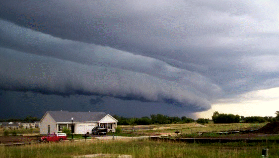

suffragette
(12,232 posts)

Hassin Bin Sober
(26,330 posts) malaise
(269,054 posts) 
limpyhobbler
(8,244 posts)Blew down a church & blew roofs off several buildings. Power was out for 10 days.
Storm pics:
http://sync.democraticunderground.com/1071235
http://sync.democraticunderground.com/1071236
limpyhobbler
(8,244 posts)These can be pretty serious
http://en.wikipedia.org/wiki/June_2012_North_American_derecho

Response to WCGreen (Original post)
OhioChick This message was self-deleted by its author.
Fuddnik
(8,846 posts)I was in boot camp in Great Lakes, Ill.
It hit us in the afternoon. It hit Cleveland just as everyone was gathering at Edgewater Park for the fireworks.
Back then, they didn't have much forecasting capability. No satellites, weather radar. It took Cleveland by surprise.
nadinbrzezinski
(154,021 posts)they are supposed to be extremely rare.
WOW.

backscatter712
(26,355 posts)Thank the Koch Bros. and the rest of the fossil fuel industry for repeat Derechos.

niyad
(113,348 posts)I know what you mean--like we need more stuff to worry about. be safe, and keep checking in.

kentuck
(111,103 posts)...we have a huge fire out in Black Forest and they have lost about 100 homes. People are being very generous. The Flying W Ranch offered stable space for all those with horses, and just about everybody out in Black Forest have horses, but the Flying W was in last year's Waldo Canyon fire and have not yet totally rebuilt. They found a small fawn, about a week old, they estimate, and the animal shelter took it. The fire is still burning.
freshwest
(53,661 posts)
WCGreen
(45,558 posts)It's just starting to roll in now. Lighting out over the lake right now...
freshwest
(53,661 posts)Thor_MN
(11,843 posts)Didn't generate enough fear, and more importantly, ratings. So bring on technical terms for weather that we have been experiencing forever. That's not to say that our weather isn;t getting more extreme, but hyping derecho is more about ratings than anything else.

AtheistCrusader
(33,982 posts)
justiceischeap
(14,040 posts)wasn't about ratings. I was without power for close to a week. It did a lot of damage. I will give you that weather "news" has become more sensational of late but a derecho can be just as dangerous as a tornado. As a matter of fact, when the Derecho tore through here last year, I thought it was a precursor to a tornado.
Thor_MN
(11,843 posts)I'm talking a 3.5 foot diameter Ash and 5 foot diameter Maple. I know storms can be dangerous. I was without power for a week with the first until they hung a new transformer to replace the one my maple took out.
I never said the storm was about ratings, I said the word derecho is about ratings. My point is that the term has existed for 125 years, yet most people had not heard of it until this year. The storms have ALWAYS been there, but the term derecho is being hyped this year. One couldn't hear live media yesterday without encountering the word derecho.
Fire Walk With Me
(38,893 posts)
Snake Plissken
(4,103 posts)Turn off your TV
malaise
(269,054 posts)Botany
(70,516 posts)It killed many people and more died in the after effects of no power and no AC ....
one county east of me 4 seniors died.
Derecho are inland hurricanes caused by the increased energy in the atmosphere
because of global climate change. Trust me they are very real.

ohheckyeah
(9,314 posts)last year. Power out all over, trees down....it was a mess. We spent a number of nights in a motel that we lucked into. The second the power went out we made reservations. We were lucky enough for the motel to come up with a room for my parents and my brother shared the room with my husband and I. Most of the motels were sold out within 2 hours within a 60 mile radius.
Response to WCGreen (Original post)
muntrv This message was self-deleted by its author.

frylock
(34,825 posts)i had to look it up, and now it's happening. I don't wanna live in this world anymore.
TorchTheWitch
(11,065 posts)And I've lived in the Mid-Atlantic region my whole life. Don't recall the weather folk ever using the word before.
Sounds to me like a new scary word that means the same thing as "high winds" "gale force winds" or whatever we've always heard before. Just another excuse to get people unnecessarily afraid as if this is some kind of new extra scary thing when it's the same crappy weather we've always had.

one_voice
(20,043 posts)one hit last year. The area my sister was in got messed up pretty bad. Good luck to you, stay safe.

I'm in the red zone

undergroundpanther
(11,925 posts)ugh.

dipsydoodle
(42,239 posts)CHICAGO (AP) — A massive storm system originally forecast to affect one in five Americans from Iowa to Maryland surged Thursday toward the Mid-Atlantic after largely failing to live up to its billing in ferocity through the Upper Midwest.
Authorities in Ohio reported early Thursday morning that high winds from possible tornadoes had damaged barns in the northwest and knocked out power in some areas in the center of the Buckeye State.
Meteorologists warned about the possibility of a weather event called a derecho (deh-RAY'-choh), which is a storm of strong straight-line winds spanning at least 240 miles.
By early Thursday, a derecho hadn't developed. And Greg Carbin of the National Weather Service's Storm Prediction Center in Norman, Okla., said, "With each hour that goes by, it's less likely."
http://bigstory.ap.org/article/massive-storm-system-surges-toward-mid-atlantic

AngryOldDem
(14,061 posts)I was caught in the one that tore through the Midwest last summer, and it was one of the scariest experiences of my life.
We were doing genealogy research in a country church cemetery when I noticed the sky turning dark. No big deal, I thought -- looked like run-of-the-mill thunderstorm clouds. But then in a matter of minutes it got pitch black and the winds picked up to the point where it was hard to walk. We made it back to the car in time to watch roofing tear off a nearby building. A large metal trash can was picked up and thrown directly at the car (my side of the car) and the car was rocking. Honest to God, I thought it was a tornado.
Again -- this all happened in a matter of MINUTES.
We managed to get out onto the road, but it was blinding, driving rain. We drove away from it and saw all sorts of damage -- trees, mostly, but a barn got damaged and calves were wandering all over the road.
It's something I never want to experience again. Luckily, we avoided it yesterday.

Jamastiene
(38,187 posts)We get those in NC every summer, it seems. They cause straight line wind damage. In other words, they knock stuff down usually from west to east (here). Like all of the corn in a farmer's field will be knocked down in one direction or all the trees in an area will be knocked down in one direction. They are pretty severe at times. They can do some damage to houses as well. I wouldn't take them too lightly, but then again I have anemophobia (fear of wind/tornadoes/hurricanes). Even winds of anywhere from 30 mph or higher scare me at times. I literally get a cold chill down my spine when winds are higher than around 30 mph. Tonight, we are expecting severe thunderstorms with winds possibly in excess of 65 mph. It's going to be a long night. I hate that feeling of ice up and down my spine. It is pure torture.
WCGreen
(45,558 posts)were in the laundry room in case something happened overnight...
Turns outs we had a lot of wind, some down limbs but nothing all that dramatic.
The cats gave us a scolding for denying them sleep cuddled in warm humans...

Recursion
(56,582 posts)They're no fun.

rightsideout
(978 posts)We got hit in Maryland just outside DC. Some people couldn't get out of the neighborhood because of downed trees in the streets. We were without power for 4 days. I had a bunch of old golf cart batteries in the garage and used those for power.
I heard this line of thunderstorms isn't as wide as last year's (according to the Weather Channel) but it could spawn some tornados in the DC area. A tornado hit Woodbine Maryland a few days ago.