Welcome to DU!
The truly grassroots left-of-center political community where regular people, not algorithms, drive the discussions and set the standards.
Join the community:
Create a free account
Support DU (and get rid of ads!):
Become a Star Member
Latest Breaking News
Editorials & Other Articles
General Discussion
The DU Lounge
All Forums
Issue Forums
Culture Forums
Alliance Forums
Region Forums
Support Forums
Help & Search
General Discussion
Related: Editorials & Other Articles, Issue Forums, Alliance Forums, Region ForumsCat 4 Typhoon Utor approaching the Phillipines
http://www.wunderground.com/blog/JeffMasters/comment.html?entrynum=2485
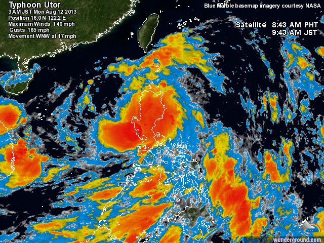
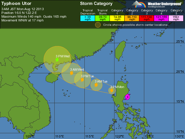
Earth's most dangerous tropical cyclone so far in 2013 is Category 4 Typhoon Utor, which is closing in on the northern Philippine Island of Luzon. Landfall is expected at approximately 20 UTC (4 pm EDT) Sunday near Casigran. Satellite imagery shows a formidable storm with well-organized spiral bands, a prominent eye, and good (but not excellent) upper-level outflow. Ocean temperatures are very warm, about 30°C (86°F), which is approximately 0.5 - 1.0°C above average. These warm waters extend to tremendous depth, giving Utor a huge source of energy to tap into. Wind shear is low, 5 - 10 knots. Theoretically, the Maximum Potential Intensity (MPI) that Utor can achieve under these conditions is sustained winds of 185 mph. However, Utor will not have time to reach that strength before encountering Luzon. The official forecast from the Joint Typhoon Warning Center calls for intensification to 140 mph winds by 18 UTC Sunday, but it is possible that Utor will have time to intensify to a 150 mph super typhoon before landfall. Utor is a very wet storm, and will likely bring a large swath of 8+ inches of rain across Luzon. These rains will cause dangerous flash flooding and mudslides. Utor will likely weaken to a Category 1 storm as it passes over Luzon, but is expected to re-intensify to a Category 2 storm before hitting China a few hundred miles south of Hong Kong about 20 UTC on Tuesday.
-----------------------------
Try and stay safe folks!!!
6 replies
 = new reply since forum marked as read
Highlight:
NoneDon't highlight anything
5 newestHighlight 5 most recent replies
Cat 4 Typhoon Utor approaching the Phillipines (Original Post)
malaise
Aug 2013
OP
greytdemocrat
(3,300 posts)1. That is a monster! nt
malaise
(283,783 posts)2. For sure
MADem
(135,425 posts)3. I've been in a few massive ti-funs in my day....and that one is a beaut!!
Look at the eye on that basstid!
malaise
(283,783 posts)4. It's only beautiful for those of us not in that eye
MADem
(135,425 posts)5. It scares the crap out of me, even thousands of miles away!
I can remember being in a heavy duty truck full of sandbags and getting hustled down the road by sheer windpower--good thing the wind and the road were going in the same direction! I saw the roof of a building fly in front of my windshield...saw another roof peeled off like a sardine can!
Like Maxwell Smart sez; Missed me by THAT much!
I will say, though, out in PI, Guam, Japan, etc., they know how to build to withstand that kind of weather--reinforced concrete, and plenty of it!
Wednesdays
(20,492 posts)6. Oh wow
Winds of 140+ mph.

Looks like it'll still be a strong storm when it hits mainland China, and it could even threaten Hong Kong.
