General Discussion
Related: Editorials & Other Articles, Issue Forums, Alliance Forums, Region ForumsTime to keep an eye on this one
1. CLOUDINESS AND SHOWERS EXTENDING FROM THE SOUTHWESTERN CARIBBEAN
SEA NORTHEASTWARD ACROSS MOST OF THE CENTRAL CARIBBEAN TO NEAR
HISPANIOLA ARE ASSOCIATED WITH A TROPICAL WAVE AND A BROAD AREA OF
LOW PRESSURE INTERACTING WITH AN UPPER-LEVEL TROUGH. ENVIRONMENTAL
CONDITIONS ARE FORECAST TO GRADUALLY BECOME MORE CONDUCIVE FOR
DEVELOPMENT OVER THE NEXT SEVERAL DAYS AS THE LARGE DISTURBANCE
MOVES TOWARD THE YUCATAN PENINSULA AND THE SOUTHERN GULF OF MEXICO.
THIS SYSTEM HAS A LOW CHANCE...NEAR 10 PERCENT...OF BECOMING A
TROPICAL CYCLONE DURING THE NEXT 48 HOURS...AND A MEDIUM CHANCE...
30 PERCENT...OF BECOMING A TROPICAL CYCLONE DURING THE NEXT 5 DAYS.
From NOAA
Was 20% chance of becoming a TC during the next five days this morning - now 30%

We'll get a lot of well needed rain but this may be problems for mainland USA down the line - keep an eye on this system
 = new reply since forum marked as read
Highlight:
NoneDon't highlight anything
5 newestHighlight 5 most recent replies
= new reply since forum marked as read
Highlight:
NoneDon't highlight anything
5 newestHighlight 5 most recent replies

TheCowsCameHome
(40,168 posts)

malaise
(268,961 posts)
TheCowsCameHome
(40,168 posts)I can't process any more than that.
Let's hope that storm fizzles out. And those nuts do, too.

steve2470
(37,457 posts)malaise
(268,961 posts)as we approach the cusp of peak season

freshwest
(53,661 posts)This is their third cruise and they like to check out all the Mayan sites around the Caribbean.
malaise
(268,961 posts)Jeff Masters
Caribbean tropical wave may develop when it reaches the Gulf of Mexico
A tropical wave in the Central Caribbean is kicking up disorganized heavy thunderstorms over Jamaica today, and this activity will spread westwards into the Cayman Islands by Wednesday, and into Mexico's Yucatan Peninsula and Western Cuba by Thursday. Wind shear is a very high 30 - 40 knots over the the wave, making development very unlikely through Wednesday. However, once the wave reaches the Western Caribbean on Thursday and pushes into the Gulf of Mexico on Friday, the wave will find a region with lower wind shear, and a strong tropical disturbance capable of becoming a tropical storm could form. If a tropical depression or tropical storm does form, and its circulation extends high above the surface, a trough of low pressure over the northern Gulf of Mexico would likely steer the storm northwards to a landfall between Eastern Louisiana and the Florida Panhandle. This is the solution presented by the Navy's 00Z run of the NAVGEM model, which shows a landfall on Saturday of a moderate-strength tropical storm. The other reliable models for genesis--the GFS, European, and UKMET--do not develop the system, or show very weak development. The European model takes much of the wave's moisture west-northwest across the Gulf of Mexico over the weekend, but the other models show the main moisture heading northwards into the Southeast U.S. Soils across the Southeast U.S. are already saturated, and tropical moisture from this storm system will be capable of dumping a large area of 4+" of rain, potentially causing significant flooding over the weekend. In their 8 am EDT Tuesday Tropical Weather Outlook, NHC gave the system a 30% of developing by Sunday, and a 10% chance of developing by Thursday. The Hurricane Hunters are on call to investigate the system on Thursday.
http://www.wunderground.com/blog/JeffMasters/comment.html?entrynum=2487
--------------
Lots of rain but no thunderstorms thus far.
freshwest
(53,661 posts)malaise
(268,961 posts)THE BROAD AREA OF LOW PRESSURE IN THE NORTHWESTERN CARIBBEAN SEA IS
MOVING TOWARD THE WEST-NORTHWEST AT 10 TO 15 MPH. CLOUDINESS AND
SHOWERS ASSOCIATED WITH THIS LOW CONTINUE TO SHOW SIGNS OF
ORGANIZATION...AND A TROPICAL DEPRESSION COULD FORM BEFORE THE
DISTURBANCE REACHES THE YUCATAN PENINSULA ON THURSDAY. AFTER
THAT...THIS WEATHER SYSTEM IS FORECAST TO MOVE OVER THE GULF OF
MEXICO...WHERE UPPER-LEVEL WINDS WILL LIKELY BE A LITTLE LESS
FAVORABLE FOR DEVELOPMENT. THIS SYSTEM HAS A HIGH CHANCE...60
PERCENT...OF BECOMING A TROPICAL CYCLONE DURING THE NEXT 48
HOURS...AND A HIGH CHANCE...70 PERCENT...OF BECOMING A TROPICAL
CYCLONE DURING THE NEXT 5 DAYS. REGARDLESS OF WHETHER OR NOT A
TROPICAL CYCLONE FORMS...HEAVY RAINS AND GUSTY WINDS ARE FORECAST
TO SPREAD OVER THE YUCATAN PENINSULA AND BELIZE DURING THE NEXT DAY
OR TWO...AND INTERESTS IN THESE AREAS SHOULD MONITOR THE PROGRESS
OF THIS DISTURBANCE.
From NOAA
steve2470
(37,457 posts)sakabatou
(42,152 posts)steve2470
(37,457 posts)sakabatou
(42,152 posts)malaise
(268,961 posts)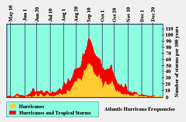

spanone
(135,829 posts)
malaise
(268,961 posts)FOR THE NORTH ATLANTIC...CARIBBEAN SEA AND THE GULF OF MEXICO...
1. A TROPICAL WAVE OVER THE WESTERN CARIBBEAN SEA IS PRODUCING A LARGE
AREA OF CLOUDINESS...SHOWERS...AND A FEW THUNDERSTORMS EXTENDING
FROM CENTRAL AMERICA NORTHEASTWARD TO JAMAICA AND EASTERN CUBA.
UPPER-LEVEL WINDS HAVE BECOME MORE FAVORABLE...AND SOME DEVELOPMENT
OF THIS DISTURBANCE IS POSSIBLE OVER THE NEXT COUPLE OF DAYS AS IT
MOVES NORTHWESTWARD AT 10 TO 15 MPH TOWARD THE YUCATAN PENINSULA
AND SOUTHERN GULF OF MEXICO. ENVIRONMENTAL CONDITIONS COULD BE A
LITTLE MORE MARGINAL FOR DEVELOPMENT WHILE THE SYSTEM IS OVER THE
GULF OF MEXICO LATER THIS WEEK. THIS SYSTEM HAS A MEDIUM CHANCE...
30 PERCENT...OF BECOMING A TROPICAL CYCLONE DURING THE NEXT 48
HOURS...AND A MEDIUM CHANCE...40 PERCENT...OF BECOMING A TROPICAL
CYCLONE DURING THE NEXT 5 DAYS.
2. A TROPICAL WAVE JUST OFF THE WEST COAST OF AFRICA IS PRODUCING
DISORGANIZED SHOWER AND THUNDERSTORM ACTIVITY. ENVIRONMENTAL
CONDITIONS APPEAR CONDUCIVE FOR SOME DEVELOPMENT OF THIS SYSTEM
DURING THE NEXT COUPLE OF DAYS BEFORE IT REACHES COOLER WATER AND
DRIER AIR BY THE WEEKEND. THIS SYSTEM HAS A LOW CHANCE...20
PERCENT...OF BECOMING A TROPICAL CYCLONE DURING THE NEXT 48
HOURS...AND A MEDIUM CHANCE...30 PERCENT...OF BECOMING A TROPICAL
CYCLONE DURING THE NEXT 5 DAYS AS IT MOVES WEST-NORTHWESTWARD AT
ABOUT 10 MPH.