Tropical Storm Chantal forms off South Carolina's coast
Source: CBS News
Updated on: July 5, 2025 / 3:45 PM EDT
Tropical Storm Chantal formed Saturday morning about 150 miles off the coast of South Carolina, prompting tropical storm warnings for portions of the Carolinas.
The National Weather Service in Miami said the storm was located south-southeast of Charleston, South Carolina and about 240 miles south-southwest of Wilmington, North Carolina. It had maximum sustained winds of 40 mph and was moving at about 2 mph.
Forecasters said the storm is expected to turn to the northeast by Sunday night and the center of Chantal is expected to move across the coast of South Carolina that day.
"Some additional strengthening is expected before Chantal reaches the coast," the NWS said. South Carolina Emergency Management Division said they expect the storm begin impacting the state on Saturday, bringing heavy rain, isolated flash flooding, gusty winds, and high rip currents through Monday.
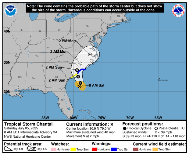
This is the 5-day prediction cone for Tropical Storm Chantal.
NOAA/National Hurricane Center
Read more: https://www.cbsnews.com/news/tropical-storm-chantal-forms-south-carolina-coast/
The track has obviously changed since the one shown in the image in the OP article. The below is the latest at post time.

 = new reply since forum marked as read