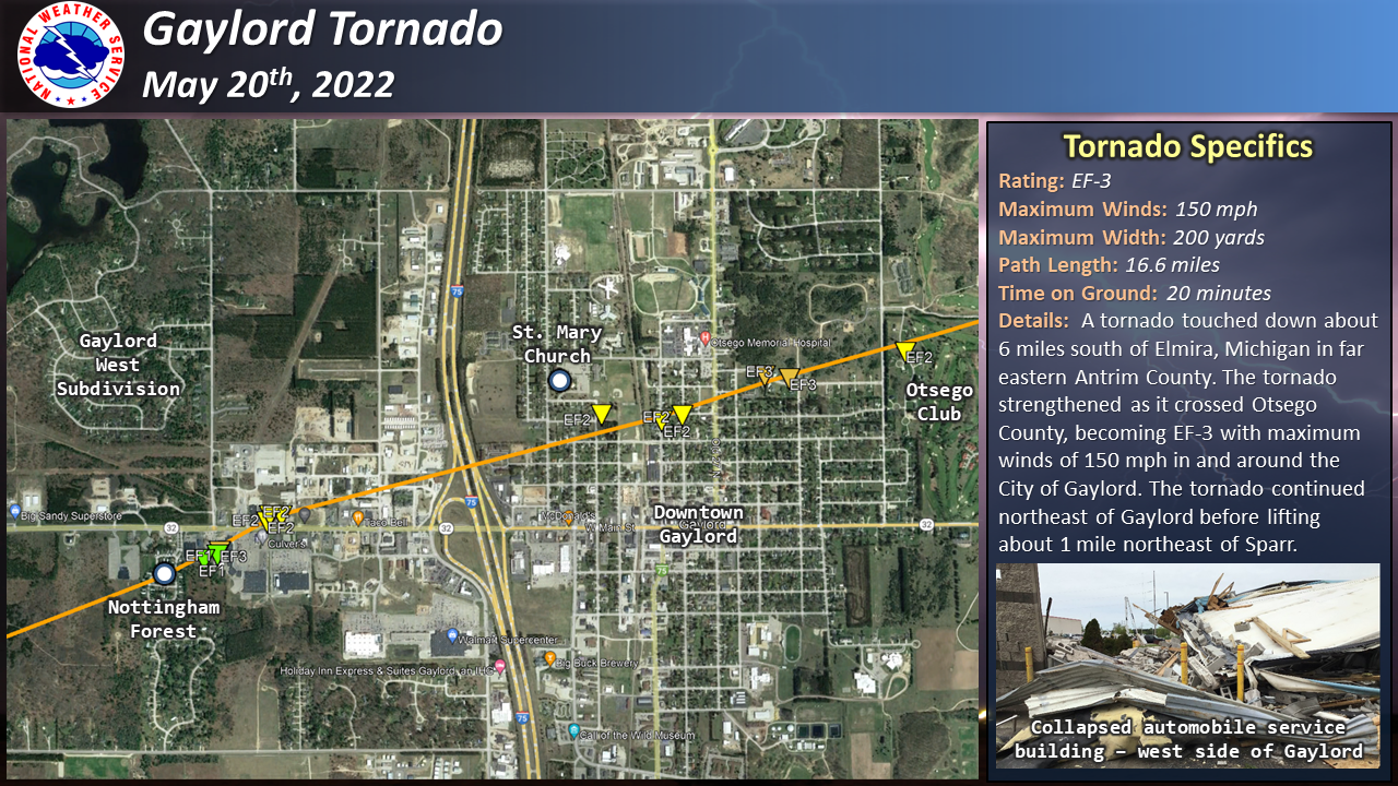
Gaylord Tornado rated an EF-3 with winds of 150 mph.
From the NWS Gaylord:
Recap of Severe Weather: May 20th, 2022
Multiple thunderstorms tracked across northern Michigan during the afternoon, including a supercell thunderstorm that produced the tornado that hit the town of Gaylord along with very large hail in other parts of the area.
Setting the stage for severe weather was a trough that rotated across the upper Midwest that developed and strengthened surface low pressure west of Lake Michigan. This system helped draw a warm, moist airmass northward across the state that helped provide the instability necessary to support severe thunderstorms later in the day. Storms initially formed along the cold front across Wisconsin during the morning hours and moved northeast across Lake Michigan, making it into the forecast area by early afternoon. The strongest line segment generated a measured wind gust of 76 mph at Frankfort Light and continued to produce damaging wind gusts across Leelanau and Antrim counties as it quickly moved northeast.
As this segment moved further away from the cold front, it began to transition into a supercell thunderstorm. This storm moved east-northeast across a very favorable environment in place across northern lower Michigan, eventually producing a tornado that caused considerable damage in the city of Gaylord. This supercell continued to trek across the area, producing baseball-sized hail in Posen.
A special weather balloon launch was conducted at 3 PM EDT to get a better look at the environment in place ahead of the approaching storm. The data from this balloon launch displayed a rare environment in place that was supportive of storms producing damaging wind gusts, very large hail, and tornadoes. Specifically, the data showed ample instability in place. This is measured by a variable called Convective Available Potential Energy (CAPE), where values were near 2,000 Joules/kilogram. Very strong wind shear was also in place, which is a measure of the change in wind speed and direction with height in the atmosphere. Almost 60 knots of shear was measured from the surface to 6 km above ground level. Storm-relative helicity (SRH), a variable that shows the tendency of the air being drawn into the storm to spin, had values of almost 300 meters^2/second^2. The magnitude of all of these variables are very high, supportive for supercell thunderstorm development and severe weather. Additionally, it is very rare for this magnitude of all of these variables to come together at once across northern Michigan.
 [/img
[/img
https://www.weather.gov/apx/severe-2022May20
This is what an EF-3 tornado can do to a mobile home: