Environment & Energy
Related: About this forumPNW Facing Up To 2 Feet Of Rain; Supertyphoon Remnants Part Of Jet Stream Package
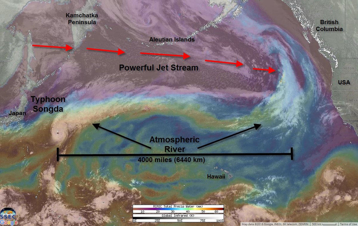
As the U.S. East Coast is still reeling from impacts associated with Hurricane Matthew, the Pacific Northwest is just now confronting its own potential extreme climate event. For a 4,000 mile long river of moisture streaming off ex super typhoon Songda in the Pacific Ocean is now firing a barrage of storms at Northern California, Oregon, Washington, and British Columbia. A series of storms that could, over the next five days, dump as much as two feet of rainfall over parts of this region.
 ?w=900&h=570
(A powerful atmospheric river is forming over the record hot Pacific Ocean in a record hot atmosphere. Typhoon Songda is delivering a great deal of tropical moisture to this flow — which is expected to impact the Pacific Northwest and produce very heavy rainfall this week. Image source: Weatherbug.)
Jet stream winds running across the Pacific now range between 180 and 220 mph. These strong winds are producing a powerful storm track even as they are tapping a vast plume of tropical moisture over the Eastern Pacific. Embedded in this moisture plume is the rain-rich ex supertyphoon Songda. As the strong upper level winds pull in Songda and draw on the extreme moisture bleed rising up off the record-hot waters of the Pacific Ocean, forecasters expect a resulting atmospheric river to run 4,000 miles across the Pacific Ocean and deliver storm after powerful storm to the Pacific Northwest.
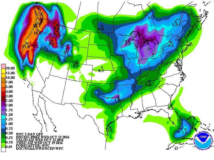
NOAA model forecasts now show as much as 22 inches of rain falling upon parts of this region over the coming 7 days. However, with so much moisture loading up the atmosphere, it’s possible that locally higher amounts of rainfall will occur.
 ?w=900&h=675
(Very heavy rains in the range of 7-22 inches or more are expected to fall over the Pacific Northwest this week in associate with a powerful river of moisture streaming off the record-hot Pacific Ocean. Image source: NOAA.)
EDIT
https://robertscribbler.com/2016/10/12/four-thousand-mile-long-river-of-moisture-could-dump-2-feet-of-rain-on-the-pacific-northwest/
 = new reply since forum marked as read
Highlight:
NoneDon't highlight anything
5 newestHighlight 5 most recent replies
= new reply since forum marked as read
Highlight:
NoneDon't highlight anything
5 newestHighlight 5 most recent replies

pscot
(21,024 posts)harder than I've ever seen here in Washington. Tropical intensity, and the Typhoon is still offshore.

NNadir
(33,533 posts)While I'm sure nobody wants more than a foot of rain in a weekend; it's not all bad. I'm sure that even in the normally wet Northwest there are reservoirs that are low.
The storm does seem to be depositing some snow in the Northern Sierra Nevadas too. It's badly needed there as well.