Welcome to DU!
The truly grassroots left-of-center political community where regular people, not algorithms, drive the discussions and set the standards.
Join the community:
Create a free account
Support DU (and get rid of ads!):
Become a Star Member
Latest Breaking News
General Discussion
The DU Lounge
All Forums
Issue Forums
Culture Forums
Alliance Forums
Region Forums
Support Forums
Help & Search
Environment & Energy
Related: About this forumNSIDC - Record Daily Lows For Arctic Ice Extent July/August; Northern Sea Route Still Open 9/30
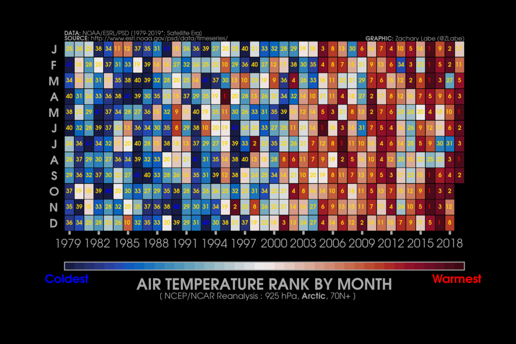
This graphic ranks months based on their Arctic air temperature from 1979 to 2019 at 925 hPa from the National Centers for Environmental Prediction/National Center for Atmospheric Research (NCEP/NCAR) Reanalysis for all areas north of 70 degrees N. Dark reds indicate warmest months; dark blues indicate coldest months. Graphic: Zachary Labe / University of California, Irvine
3 October 2019 (NSIDC) – Arctic sea ice began its autumn regrowth in the last 12 days of September, with the ice edge expanding along a broad front in the western Arctic Ocean. Overall, the summer of 2019 was exceptionally warm, with repeated pulses of very warm air from northern Siberia and the Bering Strait.
Arctic sea ice extent for September averaged 4.32 million square kilometers (1.67 million square miles), the third lowest in the 41-year continuous satellite record, behind 2012 and 2007. This is 750,000 square kilometers (290,000 square miles) above the record low set in September 2012, and 2.09 million square kilometers (807,000 square miles) below the 1981 to 2010 average. Following the minimum seasonal extent, which occurred on 18 September 2019 and tied for second lowest in the satellite record, rapid growth ensued along the ice edge in the northern Beaufort, Chukchi, East Siberian, and eastern Laptev Seas. Winds from the south caused a small area of continued ice retreat in the western Laptev and Kara Seas, offsetting some of the ice expansion. There was also growth in the Canadian Archipelago and offshore northwest of Greenland, with some expansion caused by drift to the northeast of Greenland. The Northern Sea Route appeared to still be open at the end of September.
This animation shows Arctic sea ice decline from 1979 to 2019 from pink to purple, with dark purple in 2019. This animation is based on the Chartic Interactive Sea Ice Graph. Graphic: M. Scott / NSIDC
Conditions in context
Warm conditions marked September over the entire Arctic Ocean and its surrounding lands. Air temperatures at the 925 millibar level (about 2,500 feet above sea level) for the month were 2 to 4 degrees Celsius (4 to 7 degrees Fahrenheit) above the 1981 to 2010 reference period over the ocean region, reaching 4 degrees Celsius (7 degrees Fahrenheit) above average over the Beaufort Sea north of Alaska (Figure 2b). The surrounding Eurasian high-latitude areas experienced temperatures 1 to 2 degrees Celsius (2 to 4 degrees Fahrenheit) above the reference period average. Northern Canada and Alaska were also warm, at 1 to 4 degrees Celsius (2 to 7 degrees Fahrenheit) above average, with very warm conditions over the Yukon and eastern Alaska, which experienced temperatures 4 degrees Celsius (7 degrees Fahrenheit) above average. Only southern Greenland experienced below-average temperatures, around 1 degree Celsius (2 degrees Fahrenheit) below the 1981 to 2010 period.
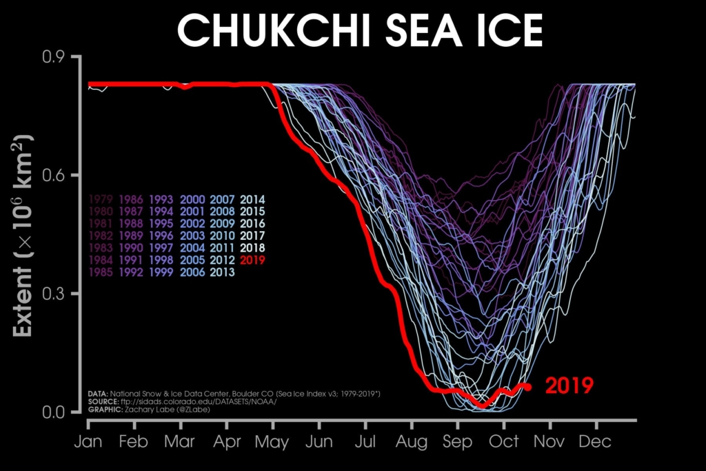
Sea ice extent in the Chukchi Sea, 1979-2019. Data for 2019 are through 19 October 2019. Graphic: Zachary Labe
A look back at the 2019 Arctic summer
Warm conditions across the Arctic Ocean, and early retreat of ice in the Chukchi and Beaufort Seas were distinguishing characteristics of the 2019 summer melt season, which followed another winter and spring with very little ice in the Bering Sea. Monthly average temperatures for the high Arctic (north of 70 degrees North latitude) show that the 2019 spring and summer months, from April to September, all ranked within the three warmest since 1979 (Figure 4a). Air temperatures at the 925hPa level over the Arctic Ocean for the period of June, July, and August were as much as 3 to 4 degrees Celsius (5 to 7 degrees Fahrenheit) above the 1981 to 2010 reference period average (Figure 4b). Similarly, warm conditions extended into central Siberia and southern Alaska. […]
The rate of sea ice decline in 2019 tracked the 2012 rate of decline for much of the summer, resulting in new record daily extent lows in July and early August for 2019. [more]
InfoView thread info, including edit history
TrashPut this thread in your Trash Can (My DU » Trash Can)
BookmarkAdd this thread to your Bookmarks (My DU » Bookmarks)
0 replies, 319 views
ShareGet links to this post and/or share on social media
AlertAlert this post for a rule violation
PowersThere are no powers you can use on this post
EditCannot edit other people's posts
ReplyReply to this post
EditCannot edit other people's posts
Rec (3)
ReplyReply to this post