Welcome to DU!
The truly grassroots left-of-center political community where regular people, not algorithms, drive the discussions and set the standards.
Join the community:
Create a free account
Support DU (and get rid of ads!):
Become a Star Member
Latest Breaking News
General Discussion
The DU Lounge
All Forums
Issue Forums
Culture Forums
Alliance Forums
Region Forums
Support Forums
Help & Search
Environment & Energy
Related: About this forumAcronym Of The Day - EPO - Eastern Pacific Oscillation And Its Impact On The "Stuck" Jet Stream
 ?w=1024
There are a number of atmospheric oscillations that are important drivers of week-to-week weather patterns across North America. The Arctic Oscillation (AO) and the North Atlantic Oscillation (NAO) often get the most attention, but one of the most important pattern oscillations for North America is the Eastern Pacific Oscillation or EPO.
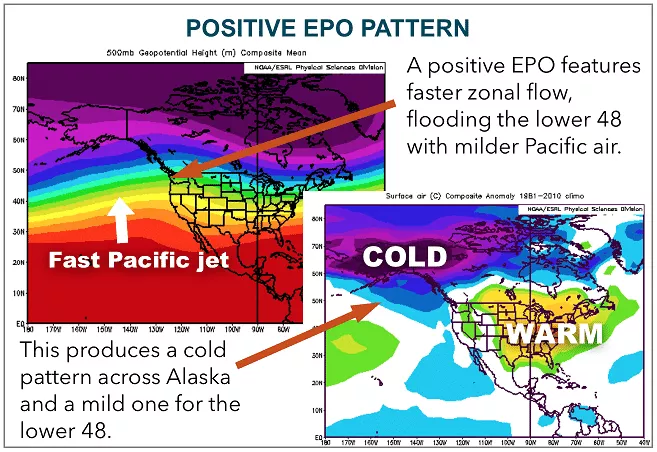
As the name implies, the EPO is a variation in the atmospheric flow pattern across the eastern Pacific, as well as Alaska. When the EPO is in a positive phase, mild Pacific air flows straight into the West Coast of North America. While such a pattern can bring significant rain and snow to the western portions of the country, the air flow warms and dries as it descends down the eastern slope of the Rockies. This results in a warmer than normal pattern across most of the central and eastern portions of the U.S. and southern Canada, particularly during the winter season. The upper level flow pattern and the distribution of warm and cold air during a positive EPO pattern is shown in the image below.
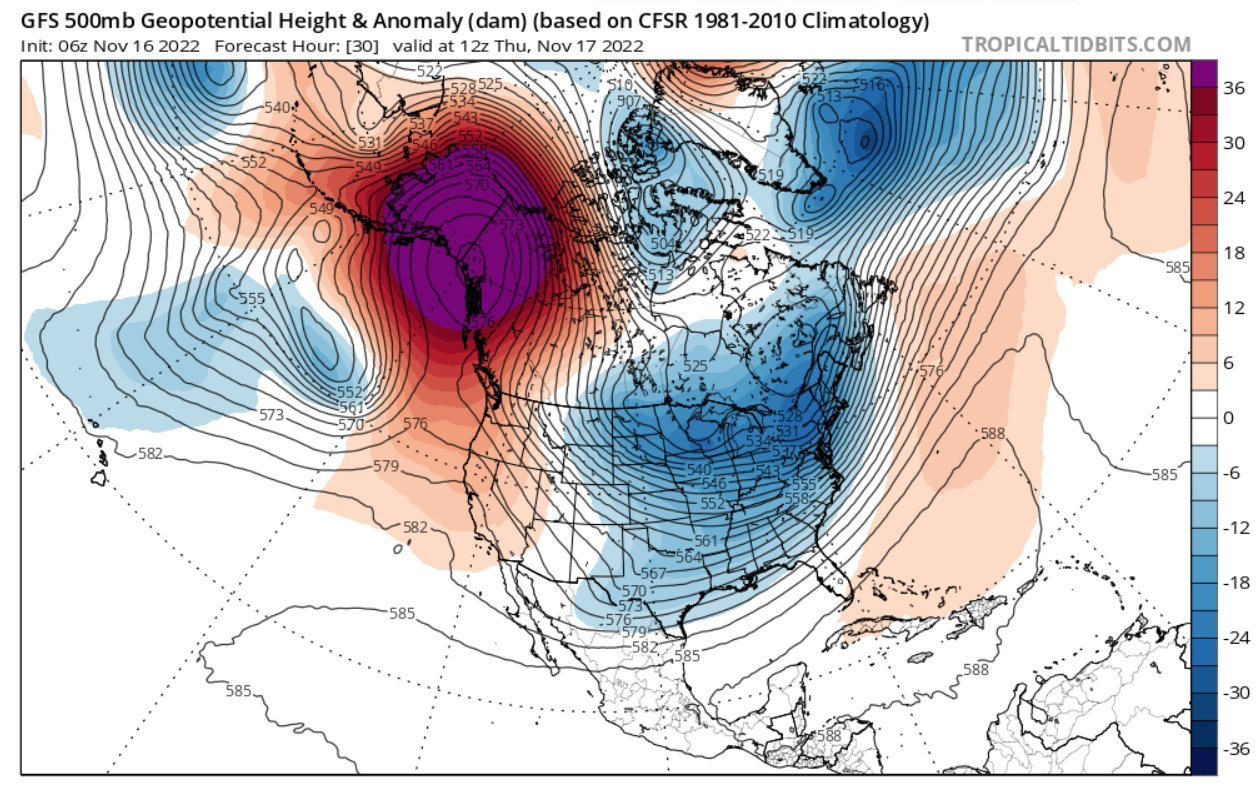
Conversely, when the EPO is in a negative phase, a ridge in the upper levels of the atmosphere is present over the eastern Pacific off the West Coast. This ridge is just an area where the air pressure, at a given altitude, is higher than in surrounding areas. That ridge of higher pressure air blocks the flow of Pacific air from reaching the West Coast. Instead, the air flows around the ridge, with a large portion of that redirected air flowing up towards Alaska and into the Arctic. As a result, when the EPO is negative, Alaska turns warmer than normal. The same ridge that turns Alaska warmer also directs more air flow southward out of the Arctic into central portions of North America. That in turn allows for cold air to build and spread southward out of Canada, resulting in a colder than normal pattern for much of Canada and the northern US. Negative EPO patterns tend to focus the strongest cold between the Rockies and Great Lakes, with the intensity and extent of the cold air largely determined by both the strength and longevity of the ridge off the West Coast. A stronger and longer lasting ridge will allow for a stronger and larger cold air mass to build, resulting in more widespread and stronger cold anomalies across the country. A typical negative EPO pattern is shown in the image below.

EDIT

Jeff Berardelli adds:

EDIT
https://climatecrocks.com/2022/11/16/this-fall-nonstop-extreme-jet-stream-weirdness/
InfoView thread info, including edit history
TrashPut this thread in your Trash Can (My DU » Trash Can)
BookmarkAdd this thread to your Bookmarks (My DU » Bookmarks)
2 replies, 579 views
ShareGet links to this post and/or share on social media
AlertAlert this post for a rule violation
PowersThere are no powers you can use on this post
EditCannot edit other people's posts
ReplyReply to this post
EditCannot edit other people's posts
Rec (7)
ReplyReply to this post
2 replies
 = new reply since forum marked as read
Highlight:
NoneDon't highlight anything
5 newestHighlight 5 most recent replies
= new reply since forum marked as read
Highlight:
NoneDon't highlight anything
5 newestHighlight 5 most recent replies
= new reply since forum marked as read
Highlight:
NoneDon't highlight anything
5 newestHighlight 5 most recent replies
Acronym Of The Day - EPO - Eastern Pacific Oscillation And Its Impact On The "Stuck" Jet Stream (Original Post)
hatrack
Nov 2022
OP

Bernardo de La Paz
(49,043 posts)1. Very interesting! . . . nt
2naSalit
(86,780 posts)2. You can see it...
Happening every day here also...
https://www.aviationweather.gov/satellite
