Nueces River (Texas) Flowed W. 2X Volume Of Niagara Falls Last Week; Extreme Rainfall Risk Has Been Underestimated
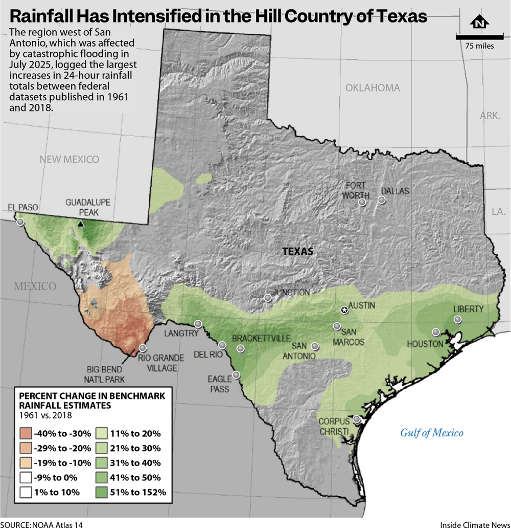
Parts of South Texas ravaged by flooding this week have logged a steep rise in rainfall intensity over recent decades, federal data show. The latest official dataset, published in 2018 by the National Oceanic and Atmospheric Administration (NOAA), increased estimates of benchmark rainfall events by 30 to 40 percent in the region west of San Antonio, an increase that was greater than almost any other part of the state.
EDIT
Last week, days of torrential downpours created the region’s second major flooding disaster in as many years. Four-day rainfall totals in the towns of Uvalde and Sabinal set records and ranked in federal models as 1,000-year rain events, with an estimated 0.1 percent chance of occurring each year. In 2025, rainfall that caused flooding on the Guadalupe River also measured as a 1,000-year event.
These models appear to be underestimating risk, said Berg, a former water resources program specialist with Texas A&M Agrilife. The next time NOAA releases data, he said, the inclusion of storms in 2025 and 2026 will further increase assessments of risk in the region. In part, Berg said, these updates reflect a better understanding of longstanding climate patterns in the region, where floods described in historical records suggest that risk was always higher than models showed. But they also indicate a changing climate. “There is a more structural question if these big events keep happening,” Berg said. “How far is it a statistical question, then how much is the ground shifting under our feet?”
EDIT
Last week in Uvalde, the Nueces River broke its alltime streamflow record, according to Greg Waller, an operational hydrologist with NOAA in Fort Worth. At its peak, the river had more than twice the flow of Niagara Falls, he said. The floods blocked state highways for days, ripped asphalt off roads, tore down one bridge, broke a berm and damaged train tracks, according to John Byrum, executive director of the Nueces River Authority. Many residents in Uvalde were evacuated before their homes flooded, he said.
EDIT
https://insideclimatenews.org/news/17072026/texas-precipitation-models-underestimate-risk/
