Science
Related: About this forumAntarctica under the ice
A new dataset called Bedmap2 gives a clearer picture of Antarctica from the ice surface down to the bedrock below. Bedmap2 is a significant improvement on the previous collection of Antarctic data — known as Bedmap — that was produced more than 10 years ago. The product was a result of work led by the British Antarctic Survey, where researchers compiled decades worth of geophysical measurements, such as surface elevation measurements from NASA’s Ice, Cloud and Land Elevation Satellite (ICESat) and ice thickness data collected by Operation IceBridge.
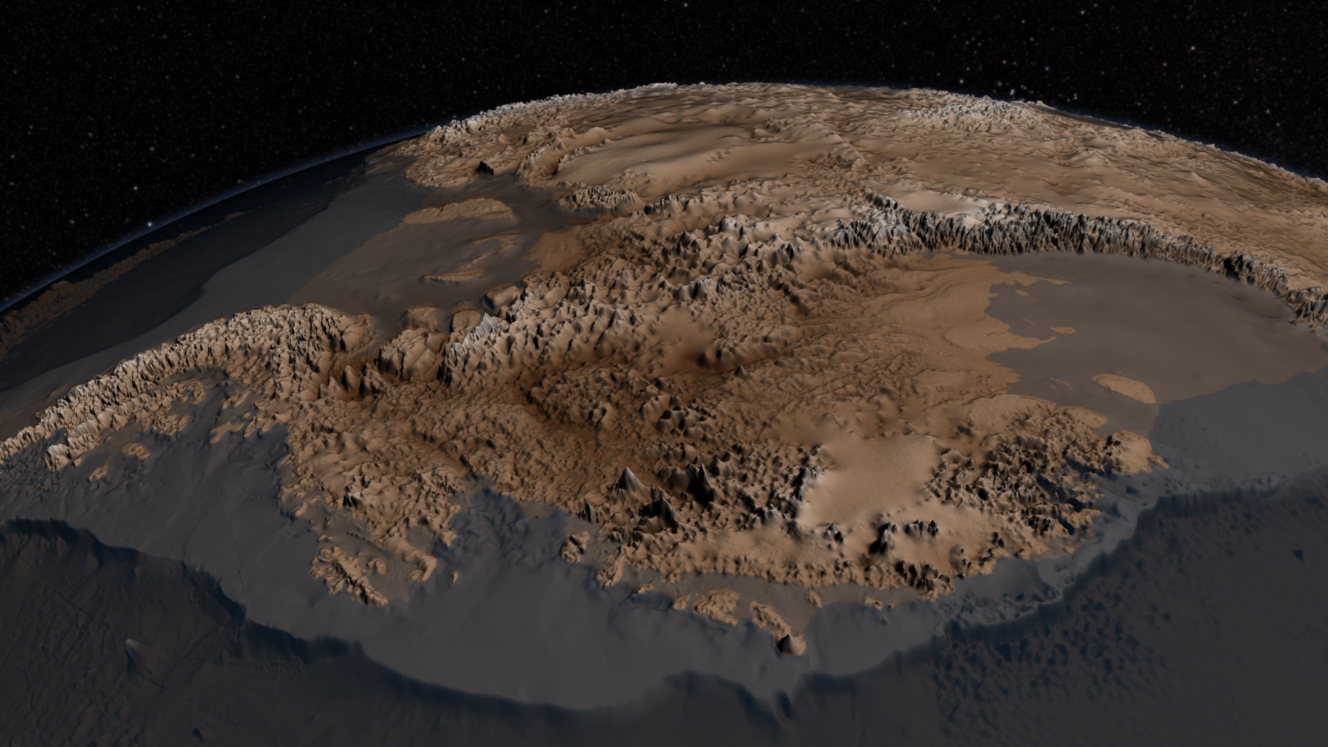
Bedmap2 data of Antarctica’s bedrock. Verical elevation has been exaggerated by 17x. (NASA/GSFC)
Read more: http://www.universetoday.com/102754/what-does-antarctica-look-like-under-the-ice/#ixzz2VYWNQCsg
 = new reply since forum marked as read
Highlight:
NoneDon't highlight anything
5 newestHighlight 5 most recent replies
= new reply since forum marked as read
Highlight:
NoneDon't highlight anything
5 newestHighlight 5 most recent replies

Socialistlemur
(770 posts)Not a perspective like this. The top view shows huge glacial valleys.

Judi Lynn
(160,545 posts)NASA's IceBridge Mission Contributes to New Map of Antarctica
by George Hale for NASA's Goddard Space Flight Center
Greenbelt MD (SPX) Jun 07, 2013
A new dataset called Bedmap2 gives a clearer picture of Antarctica from the ice surface down to the bedrock below. Bedmap2 is a significant improvement on the previous collection of Antarctic data-known as Bedmap-that was produced more than 10 years ago.
The product was a result of work led by the British Antarctic Survey, where researchers compiled decades worth of geophysical measurements, such as surface elevation measurements from NASA's Ice, Cloud and Land Elevation Satellite, known as ICESat, and ice thickness data collected by Operation IceBridge.
With effects ranging from influencing ocean currents to raising sea level, Antarctica plays a large role in the global climate system. Researchers are using a variety of methods to understand how Antarctica will react to a changing climate, but limited information on ice thickness and what lies beneath the ice makes this work challenging. Now, thanks to work led by the British Antarctic Survey published recently in the journal The Cryosphere, scientists will have a new detailed map of the frozen continent.
A Better Map
Bedmap2, like the original Bedmap, is a collection of three datasets-surface elevation, ice thickness and bedrock topography. Over the past decade there have been many Antarctic surveys, which vastly increased the amount of available data. Researchers used data from satellites, aircraft and surface-based surveys to build a data product with higher resolution, greater coverage and improved precision.
More:
http://www.terradaily.com/reports/NASAs_IceBridge_Mission_Contributes_to_New_Map_of_Antarctica_999.html

byronius
(7,395 posts)