Deny, Deflect, Delay, Lie - Even When Busted Via Satellite, Gas Well Owner Won't Admit Massive Leak [View all]
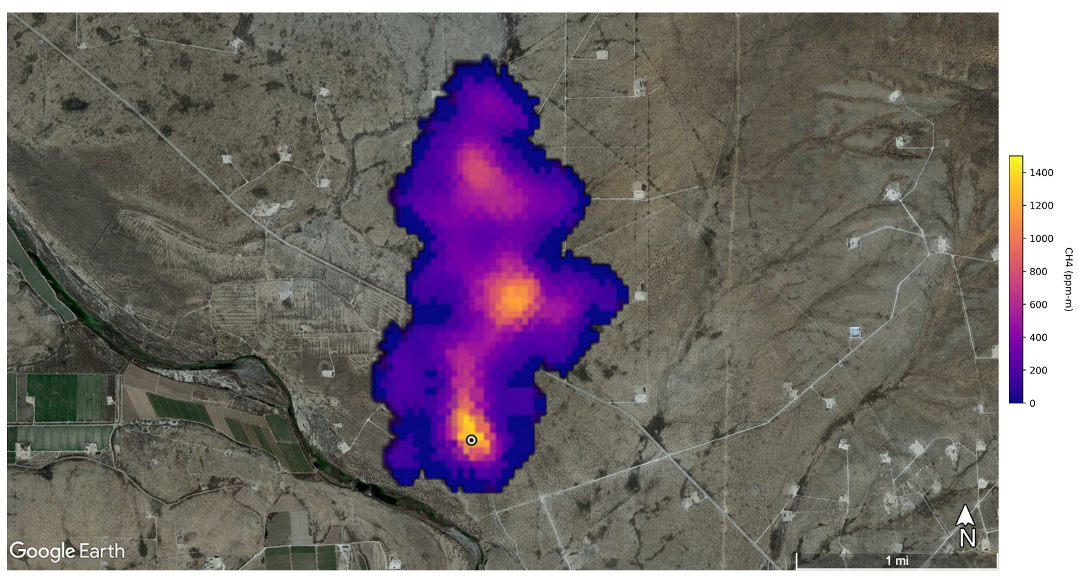 A methane plume 2 miles long detected by NASA’s Earth Surface Mineral Dust Source Investigation mission, southeast of Carlsbad, New Mexico. Image: NASA/JPL-Caltech.
A news release from NASA’s Jet Propulsion Laboratory about its new mineral mapping instrument on the International Space Station sent Oil Conservation Division (OCD) employees scrambling the last week in October. The notification, posted to science aficionados around the world, featured the agency’s new ground-scanning camera and led with an image of a massive methane leak from what appears to be a gas well along the Pecos River, 10 miles southeast of Carlsbad, New Mexico.
In the image, the leaking plume stretches just over two miles due north, a roil of angry reds and blues reflecting different concentrations of the incredibly potent greenhouse gas. Those high concentrations are why the new instrument detected the event, which it wasn’t exactly looking for. NASA’s Earth Surface Mineral Dust Source Investigation — known as EMIT — originally went to space to map minerals in this planet’s deserts, part of an effort to understand how dust from these places affects the global climate. Methane detection is a bonus.
EDIT
Overlaying the NASA image with OCD’s online Oil and Gas Map places the highest methane concentration atop Harroun Com #001, a well operated by Marathon Oil. Thorpe said the reading was made “in the July, August timeframe” but he couldn’t be specific about the date because of policies against releasing individual data points (like a single emission) before releasing a whole data set. Last year, OCD implemented new, statewide venting and flaring rules to reduce industry’s natural gas emissions to less than 2% of total production by 2026. Producers must report all natural gas that comes out of the ground and account for all venting, flaring and other emissions so that what arrives at a pipeline equals what came out of the well. Failing to report an emission like the one in the NASA image can result in fines of up to $2,500 a day, according to Hill.
Karina Brooks, a communications manager with Marathon Oil, said via an email statement, “Based on our initial review of the data, including our wells in the area, it does not appear that our operations are the source(s) of the methane emissions reflected in the photograph.” Thorpe said that high methane concentrations like those at the center of the plume indicate the source of a leak, but “that being said, there is a little bit of ambiguity.” The pixel size of the instrument’s camera records squares 60 feet across, so it can’t distinguish locations smaller than that. But the next closest well or other equipment is over 2,200 feet away from the plume’s hot spot and the Marathon well.
EDIT
https://capitalandmain.com/new-nasa-camera-spots-methane-super-emitter-in-new-mexico
 = new reply since forum marked as read