Great article at SpaceDaily:
Piecing together a global colour map of Saturn's largest moon.
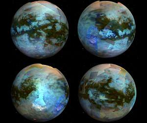
An international team led by the University of Nantes has pieced together images gathered over six years by the Cassini mission to create a global mosaic of the surface of Titan. The global maps and animations of Saturn's largest moon are being presented by Stephane Le Mouelic at the EPSC-DPS Joint Meeting 2011 in Nantes, France on Tuesday 4th October.
The team has compiled all the infrared images acquired by the Visual and Infrared Mapping Spectrometer (VIMS) during Cassini's first seventy flybys of Titan. Fitting the pieces of the puzzle together is a painstaking task.
There's an awful lot of info in this article; I'll try to summarize:
- Only a few infrared wavelengths can penetrate Titan's thick atmosphere and its clouds of methane and ethane.
- Cassini's VIMS instrument can create imaging from these wavelengths.
- Cassini orbits Saturn, not Titan, so only brief glimpses of Titan are possible maybe once a month.
- The Cassini imaging team has a daunting task to assemble these images into coherent maps of Titan.
- On the 47th flyby, Cassini was able to image the area where the Huygens probe landed, allowing for comparison between orbital remote sensing data and 'ground truth' from Huygens.
- Lakes of liquid methane in Titan's northern hemisphere were discovered by Cassini's RADAR instrument in 2006.
- The Cassini team had to wait until 2010 to obtain infrared images of these northern lakes.
- Cassini's infrared observations are providing data on the composition of these lakes. Ethane has already been identified.
For more information, visit:
The Ring World of Saturn and her moons