Democratic Underground Latest Greatest Lobby Journals Search Options Help Login
Google

'Get away from the coast now' - Hurricane Katrina ( Sunday)

Printer-friendly format Printer-friendly format
Printer-friendly format Email this thread to a friend
Printer-friendly format Bookmark this thread
This topic is archived.
Home » Discuss » Latest Breaking News Donate to DU
 
OKNancy Donating Member (1000+ posts) Send PM | Profile | Ignore Sun Aug-28-05 09:22 AM
Original message
'Get away from the coast now' - Hurricane Katrina ( Sunday)
http://www.cnn.com/2005/WEATHER/08/28/hurricane.katrina/

'Get away from the coast now'
Forecaster says Hurricane Katrina powerful, deadly

Sunday, August 28, 2005; Posted: 10:11 a.m. EDT (14:11 GMT)


Position of center: 250 miles south-southeast of the mouth of the Mississippi River

Latitude: 25.7 north

Longitude: 87.7 west

Top sustained winds: 160 mph (257 kph)

Source: National Hurricane Center SPECIAL REPORT


NEW ORLEANS, Louisiana (CNN) -- Emergency officials along the Gulf Coast urged residents to move to safer ground as powerful Hurricane Katrina churned toward shore with maximum sustained winds of 160 mph.

The National Hurricane Center in Miami said low-lying areas along the Gulf Coast could expect storm surges of up to 25 feet as the Category 5 storm makes landfall early Monday.

"It has the potential for a large loss of life," said Max Mayfield, director of the NHC. (Watch CNN meteorologist explain storm outlook)


Printer Friendly | Permalink |  | Top
OKNancy Donating Member (1000+ posts) Send PM | Profile | Ignore Sun Aug-28-05 09:26 AM
Response to Original message
1. Monster Hurricane Katrina Heads Gulf Coast
Monster Hurricane Katrina Heads Gulf Coast
By MARY FOSTER, Associated Press Writer

Hurricane Katrina strengthened to a dangerous Category 5 storm on Sunday with 160 mph sustained wind as residents of south Louisiana jammed freeways in a rush to get out of the low-lying region and head inland to higher ground.

A hurricane warning was in effect for the north-central Gulf Coast from Morgan City, La., to the Alabama-Florida, meaning hurricane conditions were expected within 24 hours, the National Hurricane Center said. Tropical storm warnings extended east to Indian Pass, Fla., and west to Cameron, La.

Katrina had been blamed for nine deaths in South Florida.

The hurricane's landfall could still come in Mississippi and affect Alabama and Florida, but it looked likely to come ashore Monday morning on the southeastern Louisiana coast, said Ed Rappaport, deputy director of the National Hurricane Center in Miami. That put New Orleans squarely in the crosshairs.

http://www.woai.com/news/local/story.aspx?content_id=F0321C5B-9BB7-49DF-86BD-AB5B9BD91A5E
Printer Friendly | Permalink |  | Top
 
magellan Donating Member (1000+ posts) Send PM | Profile | Ignore Sun Aug-28-05 09:27 AM
Response to Original message
2. I didn't understand what they meant by 'classic buzz-saw shape'
...till I saw these pix of Katrina this morning. Look at that thing. It's a beautiful killer.
Printer Friendly | Permalink |  | Top
 
SlavesandBulldozers Donating Member (1000+ posts) Send PM | Profile | Ignore Sun Aug-28-05 12:03 PM
Response to Reply #2
79. yes, buzz-saw is an apt description
Edited on Sun Aug-28-05 12:09 PM by SlavesandBulldozers
in fact, this buzz saw shape is not just evident in the satellite view.


here's an original pic of the phenomenon. Hurricane Charley's first band (it's also my DU avatar). Buzz-saw anyone?

Hurricane Charley was nothing compared to what the people of New Orlean's are in the face of. My heart goes out to them.

Edit: image resized
Printer Friendly | Permalink |  | Top
 
Up2Late Donating Member (1000+ posts) Send PM | Profile | Ignore Sun Aug-28-05 12:26 PM
Response to Reply #2
85. Here's the current "wind field" from a very good sight
Here's the link to the sight, just click on the Gulf of Mexico, and keep clicking until you get to storm level, lots of good info:

<http://tsr.mssl.ucl.ac.uk/>

Printer Friendly | Permalink |  | Top
 
Roland99 Donating Member (1000+ posts) Send PM | Profile | Ignore Sun Aug-28-05 09:28 AM
Response to Original message
3. Mayor now ordering Mandatory Evacuation of all of Orleans Parish
Printer Friendly | Permalink |  | Top
 
Sgent Donating Member (1000+ posts) Send PM | Profile | Ignore Sun Aug-28-05 09:28 AM
Response to Original message
4. First Mandatory Evacuation Ever in NOLA
Edited on Sun Aug-28-05 09:32 AM by Sgent
Just announced by Nagin (watching on wwl) www.wwl.com live hurricane coverage.

Wow....

Nagin just announced that the city take possesion of vehicles...

Last resort ppl to Superdome with other sites.

Regional Transit Authority still running for evacuation -- free transport.

Printer Friendly | Permalink |  | Top
 
jim3775 Donating Member (1000+ posts) Send PM | Profile | Ignore Sun Aug-28-05 09:28 AM
Response to Reply #4
5. CNN Live too n/t
Printer Friendly | Permalink |  | Top
 
goforit Donating Member (1000+ posts) Send PM | Profile | Ignore Sun Aug-28-05 09:43 AM
Response to Reply #4
16. All those plastic cars won't survive.
Good luck to all DUrs!!!
Printer Friendly | Permalink |  | Top
 
JoFerret Donating Member (1000+ posts) Send PM | Profile | Ignore Sun Aug-28-05 09:29 AM
Response to Original message
6. What about all those who CAN''T get out?
.
Printer Friendly | Permalink |  | Top
 
Boomer Donating Member (1000+ posts) Send PM | Profile | Ignore Sun Aug-28-05 09:37 AM
Response to Reply #6
12. I-10 is gridlocked
So the window of escape just narrowed considerably.
Printer Friendly | Permalink |  | Top
 
niallmac Donating Member (1000+ posts) Send PM | Profile | Ignore Sun Aug-28-05 09:37 AM
Response to Reply #6
13. I can't build a commercial building
without adequate fire egress conforming to code. A giant hurricane prone city without adequate egress? No problem.
Printer Friendly | Permalink |  | Top
 
JackDragna Donating Member (1000+ posts) Send PM | Profile | Ignore Sun Aug-28-05 09:36 AM
Response to Original message
7. Breaking: Mayor Nagin orders mandatory evac of New Orleans
Links will be forthcoming.
Printer Friendly | Permalink |  | Top
 
Boomer Donating Member (1000+ posts) Send PM | Profile | Ignore Sun Aug-28-05 09:36 AM
Response to Reply #7
8. About damn time
Printer Friendly | Permalink |  | Top
 
tedoll78 Donating Member (1000+ posts) Send PM | Profile | Ignore Sun Aug-28-05 09:36 AM
Response to Reply #7
9. Live feed of WWL TV..
Printer Friendly | Permalink |  | Top
 
KyndCulture Donating Member (1000+ posts) Send PM | Profile | Ignore Sun Aug-28-05 09:36 AM
Response to Reply #7
10. it's too g'damn late!!! sigh... so worried. nt
Printer Friendly | Permalink |  | Top
 
sam sarrha Donating Member (1000+ posts) Send PM | Profile | Ignore Sun Aug-28-05 09:36 AM
Response to Reply #10
11. how do the elderly, poor and homeless get out.. good plan to cleanse them
cheap and efficient
Printer Friendly | Permalink |  | Top
 
Catch22Dem Donating Member (1000+ posts) Send PM | Profile | Ignore Sun Aug-28-05 09:43 AM
Response to Reply #11
17. I'm not sure I understand...
You're not suggesting they not order the evacuation, right? You're just saying they need to provide asstiance for people who need it.
Printer Friendly | Permalink |  | Top
 
sam sarrha Donating Member (1000+ posts) Send PM | Profile | Ignore Sun Aug-28-05 10:31 AM
Response to Reply #17
48. How the hell are they going to get OUT.!!!!!!!! they have means to leave.!
no national guard to help.. not place to go and hide from 180 mph winds.. and there are THOUSANDS..!!!

how many elderly care homes with people on IV's.. who need spacial care during the move.. and care when they get to what ever place they put them in.. there evidently is no plan for the helpless.

there are thousands of homeless mentally ill hiding in back alleys living in boxes...

thousands of old folks too inferm to walk far, too sick, to confused and frightened, some have no friends or family, no support, no car.

Please Broaden your perspective....
Printer Friendly | Permalink |  | Top
 
salin Donating Member (1000+ posts) Send PM | Profile | Ignore Sun Aug-28-05 10:49 AM
Response to Reply #48
57. reminds me of the scenes in the hospital in global warming warning movie
hero's wife can't leave - due to needing to care for folks who cannot be evacuated.

But that was fiction - and one hospital (made a point for the drama) -what you refer to is real and on a very large scale - and very tragic.
Printer Friendly | Permalink |  | Top
 
Catch22Dem Donating Member (1000+ posts) Send PM | Profile | Ignore Sun Aug-28-05 10:55 AM
Response to Reply #48
59. I still don't understand what you're getting at
I agree that there are thousands of people who CAN'T get out. I recognize this fact, and there needs to be something in place to deal with this situation. What I'm asking you is, should the rest of the city STAY? Should they NOT have ordered evacuation for the people who CAN leave? Seems rather foolish. I'm not sure what you mean by broaden my perspective. Seems I'm seeing this a lot clearer than you. I get the impression you're deriding the city for trying to get a large portion of its population out of harms way.
Printer Friendly | Permalink |  | Top
 
Name removed Donating Member (0 posts) Send PM | Profile | Ignore Sun Aug-28-05 11:21 AM
Response to Reply #59
68. Deleted message
Message removed by moderator. Click here to review the message board rules.
 
Up2Late Donating Member (1000+ posts) Send PM | Profile | Ignore Sun Aug-28-05 12:07 PM
Response to Reply #48
80. The Weather Channel said the plan is to move them to the SuperDome
Edited on Sun Aug-28-05 12:07 PM by Up2Late
They said it was built to withstand 200mph Winds.

Let's hope.
Printer Friendly | Permalink |  | Top
 
JoFerret Donating Member (1000+ posts) Send PM | Profile | Ignore Sun Aug-28-05 11:22 AM
Response to Reply #11
69. Don''t think such thoughts.
.
Printer Friendly | Permalink |  | Top
 
Boomer Donating Member (1000+ posts) Send PM | Profile | Ignore Sun Aug-28-05 09:41 AM
Response to Reply #10
14. At least 24 hours too late
I don't understand what Nagin was waiting for. Weather will start to worsen about 6pm, which doesn't leave much time at all.

People who waited for the mayor to tell them what to do will suffer the cost of his slow judgment.
Printer Friendly | Permalink |  | Top
 
JackDragna Donating Member (1000+ posts) Send PM | Profile | Ignore Sun Aug-28-05 09:45 AM
Response to Reply #14
18. Most people who could easily get out are already in the process.
Unfortunately, most of those about to die were going to die no matter what happened. The seeds were this were planted by years of doing nothing to adequately prepare the city.
Printer Friendly | Permalink |  | Top
 
SlavesandBulldozers Donating Member (1000+ posts) Send PM | Profile | Ignore Sun Aug-28-05 11:16 AM
Response to Reply #7
66. sending prayers and positive vibes to New Orleans
you will make it through, New Orleans. You always do. Please do keep us updated, and let us know how we can help. This is about the worst-case scenario for a hurricane in the gulf. New Orleans is a beautiful city with great people - they will get through this. The poor of New Orleans, and the elderly, are going to need a lot of help in the coming days, months, and years ahead.
Printer Friendly | Permalink |  | Top
 
nodehopper Donating Member (1000+ posts) Send PM | Profile | Ignore Sun Aug-28-05 11:58 AM
Response to Reply #7
77. ABOUT FREAKING TIME, except that, you know, too late
Printer Friendly | Permalink |  | Top
 
shawmut Donating Member (1000+ posts) Send PM | Profile | Ignore Sun Aug-28-05 09:42 AM
Response to Original message
15. Pressure has dropped again - 907mb/26.78"
new recon just reported that within the past few minutes.
Printer Friendly | Permalink |  | Top
 
KyndCulture Donating Member (1000+ posts) Send PM | Profile | Ignore Sun Aug-28-05 10:09 AM
Response to Reply #15
27. my god... that's awful!!!
Printer Friendly | Permalink |  | Top
 
Up2Late Donating Member (1000+ posts) Send PM | Profile | Ignore Sun Aug-28-05 12:18 PM
Response to Reply #15
84. Just for comparison, Hurricane Camille 1969 got down to 9.09/26.84
Edited on Sun Aug-28-05 12:19 PM by Up2Late
...or it might have been 9.02, it was late when they said it on the Weather Channel.

If anyone knows how to convert "Inches of Mercury," this site says, "...A minimum pressure of 26.84 inches was reported in Bay St. Louis, Mississippi..."

<http://www.nhc.noaa.gov/HAW2/english/history.shtml#camille>
Printer Friendly | Permalink |  | Top
 
shawmut Donating Member (1000+ posts) Send PM | Profile | Ignore Sun Aug-28-05 09:46 AM
Response to Original message
19. The winds are up to 175mph sustained!
Hurricane Katrina Advisory Number 23

Statement as of 10:00 am CDT on August 28, 2005

...Potentially catastrophic Hurricane Katrina...even
stronger...headed for the northern Gulf Coast...

A Hurricane Warning is in effect for the north central Gulf Coast
from Morgan City Louisiana eastward to the Alabama/Florida
border...including the city of New Orleans and Lake Pontchartrain.
A Hurricane Warning means that hurricane conditions are expected
within the warning area within the next 24 hours. Preparations to
protect life and property should be rushed to completion.


A Tropical Storm Warning and a Hurricane Watch are in effect from
east of the Alabama/Florida border to Destin Florida...and from
west of Morgan City to Intracoastal City Louisiana. A Tropical
Storm Warning means that tropical storm conditions are expected
within the warning area within the next 24 hours. A Hurricane Watch
means that hurricane conditions are possible within the watch
area...generally within 36 hours.


A Tropical Storm Warning is also in effect from Destin Florida
eastward to Indian Pass Florida...and from Intracoastal City
Louisiana westward to Cameron Louisiana.


For storm information specific to your area...including possible
inland watches and warnings...please monitor products issued
by your local weather office.


At 10 am CDT...1500z...the center of Hurricane Katrina was located
near latitude 26.0 north... longitude 88.1 west or about 225 miles
south-southeast of the mouth of the Mississippi River.


Katrina is moving toward the west-northwest near 12 mph...and a turn
toward the northwest and north-northwest is expected over the next
24 hours.


Reports from an Air Force hurricane hunter aircraft indicate that
the maximum sustained winds have increased to near 175 mph...with
higher gusts. Katrina is a potentially catastrophic category five
hurricane on the Saffir-Simpson scale. Some fluctuations in
strength are likely during the next 24 hours.


Hurricane force winds extend outward up to 105 miles from the
center...and tropical storm force winds extend outward up
to 205 miles.


The Air Force hurricane hunter plane recently measured a minimum
central pressure of 907 mb...26.78 inches.

Coastal storm surge flooding of 18 to 22 feet above normal tide
levels...locally as high as 28 feet along with large and dangerous
battering waves...can be expected near and to the east of where the
center makes landfall.


Rainfall totals of 5 to 10 inches...with isolated maximum amounts of
15 inches...are possible along the path of Katrina across the Gulf
Coast and the Tennessee Valley. Rainfall totals of 4 to 8 inches
are possible across the Ohio Valley into the eastern Great Lakes
region Tuesday and Wednesday.

Isolated tornadoes will be possible beginning this evening over
southern portions of Louisiana...Mississippi...and Alabama...and
over the Florida Panhandle.

Repeating the 10 am CDT position...26.0 N... 88.1 W. Movement
toward...west-northwest near 12 mph. Maximum sustained winds...
175 mph. Minimum central pressure... 907 mb.


An intermediate advisory will be issued by the National Hurricane
Center at 1 PM CDT followed by the next complete advisory at 4 PM
CDT.


Forecaster Pasch
Printer Friendly | Permalink |  | Top
 
jus_the_facts Donating Member (1000+ posts) Send PM | Profile | Ignore 
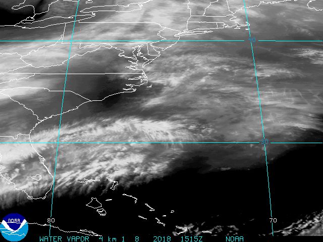
Sun Aug-28-05 09:48 AM
Response to Reply #19
20. here's the latest satellite shot....
Printer Friendly | Permalink |  | Top
 
Copperred Donating Member (554 posts) Send PM | Profile | Ignore Sun Aug-28-05 10:12 AM
Response to Reply #20
38. The latest satellite shot?


Where do you get the very latest satellite shots?

Thanks
Printer Friendly | Permalink |  | Top
 
jus_the_facts Donating Member (1000+ posts) Send PM | Profile | Ignore Sun Aug-28-05 10:14 AM
Response to Reply #38
39. GOES...from NOAA.....
Printer Friendly | Permalink |  | Top
 
Sgent Donating Member (1000+ posts) Send PM | Profile | Ignore Sun Aug-28-05 09:50 AM
Response to Original message
21. Couple of reasons
1) This is the FIRST mandatory evacuation of all people in the history of City.

2) Even now, hospitals, hotels, and jails, are still exempted.

3) 30% don't have a good way to evacuate. NOLA is possibly one of the better walking cities in the country -- certainly in the south.

4) Prevention of panic.

5) Most hurricanes get pushed eastward by the MS River.

6) Winds aren't really an issue per se. Its the water. High winds hit 2-3 times a year in NOLA, and buildings are built to handle it (at least the large ones where most evacuate too).
Printer Friendly | Permalink |  | Top
 
Esse Quam Videri Donating Member (256 posts) Send PM | Profile | Ignore Sun Aug-28-05 09:55 AM
Response to Original message
22. Winds now at 175mph
Reported on both CNN and TWC
Printer Friendly | Permalink |  | Top
 
Boo Boo Donating Member (1000+ posts) Send PM | Profile | Ignore Sun Aug-28-05 10:03 AM
Response to Reply #22
25. Yeah, and those are SUSTAINED winds. Gusts are probably
in the 200 range by now. It's apparently now the 2nd largest/strongest in N. American recorded history and still growing.

Scary.
Printer Friendly | Permalink |  | Top
 
hatrack Donating Member (1000+ posts) Send PM | Profile | Ignore Sun Aug-28-05 11:30 AM
Response to Reply #25
71. The Discussion section of the NHC web page puts it in perspective
EDIT

THE AIR FORCE HURRICANE HUNTERS JUST MEASURED A 166 KT FLIGHT LEVEL
WIND IN THE NORTHEAST EYEWALL...WHICH REQUIRES AN ADDITIONAL UPWARD
ADJUSTMENT OF THE CURRENT INTENSITY TO 150 KT. A DROP IN THE EYE
GAVE A CENTRAL PRESSURE OF 907 MB. KATRINA IS COMPARABLE IN
INTENSITY TO HURRICANE CAMILLE OF 1969...ONLY LARGER.
GPS
DROPSONDE DATA FROM THE NOAA G-IV MISSION EARLIER TODAY SHOWED
KATRINA'S INTENSE CYCLONIC CIRCULATION EXTENDING THROUGH THE 200 MB
LEVEL...WITH THE FLOW SPIRALING ANTICYLONICALLY OUTWARD IN A
WELL-DEVELOPED UPPER-LEVEL OUTFLOW PATTERN BEYOND A COUPLE HUNDRED
N MI FROM THE CENTER. FLUCTUATIONS IN STRENGTH...DUE TO INTERNAL
STRUCTURAL CHANGES...ARE LIKELY PRIOR TO LANDFALL. HURRICANES
RARELY SUSTAIN SUCH EXTREME WINDS FOR MUCH TIME. HOWEVER WE SEE
NO OBVIOUS LARGE-SCALE EFFECTS TO CAUSE A SUBSTANTIAL WEAKENING THE
SYSTEM...AND IT IS EXPECTED THAT THE HURRICANE WILL BE OF CATEGORY
4 OR 5 INTENSITY WHEN IT REACHES THE COAST.


EDIT

http://www.nhc.noaa.gov/text/refresh/MIATCDAT2+shtml/281454.shtml?
Printer Friendly | Permalink |  | Top
 
Hokie Donating Member (1000+ posts) Send PM | Profile | Ignore Sun Aug-28-05 09:55 AM
Response to Original message
23. This is from Steve Gregory's Blog on Weather Underground
UGUST 28 - 9:00AM CDT URGENT UPDATE

CATASTROPHIC HURRICANE APPROACHING NEW ORLEANS REGION

The latest RECON data and Hi-RES imagery indicates Katrina is now a Record Breaking and Extremely powerful
CAT Hurricane

The storm is located 25.9N/ 87.9W -- 300 miles SSE of Gulfport, MS, and 270 miles SSE of the Mississippi Delta.
Central pressure of 908MB, an eye diameter of 22NM, and max winds of 153KTS (measured 2 hrs ago).
This implies a Max sustained surface winds of 160mph, with gusts to 190mph.

These is DEEP into CAT 5 territory. The thermal eyewall has attained a phenomenal 20degC temperature differential.

This central pressure is very close to that recorded in Camille in 1969 - the most powerful land falling hurricane in
U.S. history, with a storm surge of 25' in some locations. As surmised last evening in my final update, if the eye wall
was to shrink to 15NM diameter, we would have another Camille -- except it is a larger storm than Camille.
This storm will produce the most catastrophic damage in modern times if it maintains it's intensity and projected track.
The repercussions of which will be felt nationwide for a very long time come.

The exact track - and even the exact intensity of Katrina at landfall is still simply too difficult to predict with the
type of precision everyone would like. But the latest track consensus forecast continues to show a Katrina moving
over New Orleans proper at 2PM Monday, but striking the Mississippi Delta by around 9AM. ** IF ** Katrina
maintains CAT 5 intensity all the way to the coast, a storm surge of 24-28 feet will hit the Delta region, and near
20 feet at the entrance the Lake Borgne which lies just east of Lake Ponchartrain.The wave heights within 20 miles
of the northeast eyewall will attain 60-70 feet which will ride atop the 25 foot storm surge itself.

I will be issuing more frequent, but less detailed updates throughout the day and up through landfall.

Steve
Printer Friendly | Permalink |  | Top
 
AngryOldDem Donating Member (1000+ posts) Send PM | Profile | Ignore Sun Aug-28-05 10:01 AM
Response to Original message
24. How safe is the Superdome?
Granted, with a storm this gargantuan, nothing is disasterproof...but if they're talking about sheltering possibly tens of thousands of people (worst-case, last-resort scenario), I'm wondering how sturdy that structure is, especially the roof? Was the Superdome designed with this purpose in mind?
Printer Friendly | Permalink |  | Top
 
NYC Donating Member (1000+ posts) Send PM | Profile | Ignore Sun Aug-28-05 10:35 AM
Response to Reply #24
50. I heard that the Superdome is above sea level.
I don't know if that is true.
Printer Friendly | Permalink |  | Top
 
Massacure Donating Member (1000+ posts) Send PM | Profile | Ignore Sun Aug-28-05 11:30 AM
Response to Reply #24
70. Domes are the most sound geometric shape you can find.
Edited on Sun Aug-28-05 11:31 AM by Massacure
The Hagia Sophia in Istanbul has been standing for 1500 years. No Earthquake has taken it down yet.

Plus domes are much more aerodynamic than squares. The wind will have difficulty "grabbing" it. I think the Superdome will be fine as it is a concrete dome that is built of solid concrete and steel.

If it is used as a shelter we have to hope it does not flood.

There are no guarantees with nature, but that dome is probably their best bet.

Printer Friendly | Permalink |  | Top
 
kestrel91316 Donating Member (1000+ posts) Send PM | Profile | Ignore Sun Aug-28-05 11:50 AM
Response to Reply #70
74. If the Superdome floods they can get up into the stands, right?
Except maybe the bedridden or wheelchair-bound??
Printer Friendly | Permalink |  | Top
 
Mari333 Donating Member (1000+ posts) Send PM | Profile | Ignore Sun Aug-28-05 10:07 AM
Response to Original message
26. Live cam, getting dark there
Printer Friendly | Permalink |  | Top
 
OKNancy Donating Member (1000+ posts) Send PM | Profile | Ignore Sun Aug-28-05 10:10 AM
Response to Reply #26
36. Cool.. thanks for posting that
Printer Friendly | Permalink |  | Top
 
redirish28 Donating Member (1000+ posts) Send PM | Profile | Ignore Sun Aug-28-05 10:09 AM
Response to Original message
28. Katrina up to 175 mph and gaining strength!
Edited on Sun Aug-28-05 09:58 AM by redirish28
This is really scary! Just in from cnn tv news
Printer Friendly | Permalink |  | Top
 
mom cat Donating Member (1000+ posts) Send PM | Profile | Ignore Sun Aug-28-05 10:09 AM
Response to Reply #28
29. Mayor of New Orleans expects the levees to be toppled.
Printer Friendly | Permalink |  | Top
 
HereSince1628 Donating Member (1000+ posts) Send PM | Profile | Ignore Sun Aug-28-05 10:09 AM
Response to Reply #29
32. Toppled or topped?

Printer Friendly | Permalink |  | Top
 
redirish28 Donating Member (1000+ posts) Send PM | Profile | Ignore Sun Aug-28-05 10:09 AM
Response to Reply #29
33. forget the levees...
I expect New Orleans to not exsist as we know it if it takes a direct hit, and it look like it will! GOD help them!
Printer Friendly | Permalink |  | Top
 
AngryOldDem Donating Member (1000+ posts) Send PM | Profile | Ignore Sun Aug-28-05 10:57 AM
Response to Reply #33
61. The levees will be gone
Edited on Sun Aug-28-05 10:57 AM by AngryOldDem
Nagin said as much during his news conference this morning.

Another concern that has not been discussed is that the surge will most likely force the Mississippi to reverse course...just how far up from NO that phenomenon will happen I don't know. But apparently levees are also in place all along the Mississippi. What will happen if those also get washed out? The southern two-thirds of Louisiana could be desvastated.

I honestly can't get my mind around the potential scope of this disaster. What is very scary is that up until this point ALL forecasts have been almost 100% accurate. The only thing that has caught the experts off guard has been this sudden strengthening. I was watching the meteorologist on CNN (who also contracts with FEMA, apparently) and his face was sheet-white when he was reading the latest NOAA statement.
Printer Friendly | Permalink |  | Top
 
libertypirate Donating Member (1000+ posts) Send PM | Profile | Ignore Sun Aug-28-05 10:09 AM
Response to Reply #28
30. Navy Resource to track storm
Everything from building your own animations to seeing the likely path including potential wind speeds.

http://www.nrlmry.navy.mil/tc_pages/tc_home.html
Printer Friendly | Permalink |  | Top
 
babylonsister Donating Member (1000+ posts) Send PM | Profile | Ignore Sun Aug-28-05 10:09 AM
Response to Reply #28
31. Time for NOAA to redraw their hurricane
categories, sadly; this is heading off the charts!
Printer Friendly | Permalink |  | Top
 
jus_the_facts Donating Member (1000+ posts) Send PM | Profile | Ignore Sun Aug-28-05 10:09 AM
Response to Reply #28
34. thar she blows....
:scared:

Printer Friendly | Permalink |  | Top
 
nytemare Donating Member (1000+ posts) Send PM | Profile | Ignore Sun Aug-28-05 10:09 AM
Response to Reply #34
35. Wow. Just wow.
That is a mean looking hurricane.
Printer Friendly | Permalink |  | Top
 
jus_the_facts Donating Member (1000+ posts) Send PM | Profile | Ignore Sun Aug-28-05 10:22 AM
Response to Reply #35
44. extremely intense and takin' dead aim at Louisiana.....
.....glad I'm in the Northeast...but looks like we're in for some steady 50mph winds at least too...

Printer Friendly | Permalink |  | Top
 
Dogmudgeon Donating Member (1000+ posts) Send PM | Profile | Ignore Sun Aug-28-05 10:12 AM
Response to Reply #28
37. This is getting to be downright unsettling
The storm only hit Cat 4 this morning around 4 AM EDT -- seven hours ago. Now it's well into Cat 5. From 135 mph to 175 mph windspeed in a short time.

I don't think any storm has strengthened that much that fast.

The hurricane with the highest winds remains Camille (1969), which had sustained winds of 200 mph; the one with the deepest barometric pressure was Gilbert (1988) at 888 mB ("normal" air pressure is 1019 mB). The cloud top temperatures are as low as -150F, which is also an extremely rare occurrence.

This might actually be fascinating if so much property and so many lives weren't at risk.

--p!
Printer Friendly | Permalink |  | Top
 
karlrschneider Donating Member (1000+ posts) Send PM | Profile | Ignore Sun Aug-28-05 11:01 AM
Response to Reply #37
62. std SL pressure is 1013.25 mb
:D
Printer Friendly | Permalink |  | Top
 
Dogmudgeon Donating Member (1000+ posts) Send PM | Profile | Ignore Sun Aug-28-05 11:17 AM
Response to Reply #62
67. Thanks! I was going on memory with that one ...
--p!
Printer Friendly | Permalink |  | Top
 
karlrschneider Donating Member (1000+ posts) Send PM | Profile | Ignore Sun Aug-28-05 12:55 PM
Response to Reply #67
87. No worries, wasn't tryin' to be a smartass,
I'm a commercial pilot & aero engineer so I kinda have those little factoids burned in...
:D
Printer Friendly | Permalink |  | Top
 
FloridaPat Donating Member (1000+ posts) Send PM | Profile | Ignore Sun Aug-28-05 10:20 AM
Response to Original message
40. The entire city of New Orleans told to evacute. Katrina is Cat 5 hurricane
Printer Friendly | Permalink |  | Top
 
castiron Donating Member (376 posts) Send PM | Profile | Ignore Sun Aug-28-05 10:20 AM
Response to Reply #40
41. New Olreans web cam
Printer Friendly | Permalink |  | Top
 
wryter2000 Donating Member (1000+ posts) Send PM | Profile | Ignore Sun Aug-28-05 10:20 AM
Response to Reply #40
42. Oh, dear God
This is going to be horrible. :scared:

Take care, LA
Printer Friendly | Permalink |  | Top
 
BrklynLiberal Donating Member (1000+ posts) Send PM | Profile | Ignore Sun Aug-28-05 10:20 AM
Response to Reply #40
43. Get out and remember your pets..
Printer Friendly | Permalink |  | Top
 
Daphne08 Donating Member (1000+ posts) Send PM | Profile | Ignore Sun Aug-28-05 10:22 AM
Response to Original message
45. OMG!
I just woke up. A Category 5?

:cry:

Printer Friendly | Permalink |  | Top
 
hnsez Donating Member (430 posts) Send PM | Profile | Ignore Sun Aug-28-05 10:25 AM
Response to Original message
46. Nixon & Camille
Immediately after President Nixon sent 1,000 federal troops into the area, Governor John Williams declared martial law. Using federal troops and state police, all roads leading into the area where the eye had crossed the coast were sealed off. Military and local police imposed a curfew. The first problem to overcome was the thousands of dead farm animals, pets, and wildlife. Camille's incredible storm surge had drowned thousands of animals. Heavy equipment was brought in to bury thousands of dead cows, horses and pets. Next, insects and rodents had quickly overrun the stricken area - feeding on dead animal carcasses and rotting food. Rattlesnakes, fire ants, and rats bit dozens of victims as they sifted through the rubble. In an attempt to control fire ants, low flying spray planes roared up and down the Mississippi coast, dropping 100,000 pounds of mirex.

Printer Friendly | Permalink |  | Top
 
yardwork Donating Member (1000+ posts) Send PM | Profile | Ignore Sun Aug-28-05 10:33 AM
Response to Reply #46
49. Too bad our troops are in Iraq - as are the National Guard
bummer.
Printer Friendly | Permalink |  | Top
 
NYC Donating Member (1000+ posts) Send PM | Profile | Ignore Sun Aug-28-05 10:38 AM
Response to Reply #46
51. Thanks for that information.
I hadn't thought about the the vermin in the aftermath.
Printer Friendly | Permalink |  | Top
 
Daphne08 Donating Member (1000+ posts) Send PM | Profile | Ignore Sun Aug-28-05 10:42 AM
Response to Reply #46
56. I remember Camille.
Edited on Sun Aug-28-05 10:47 AM by Daphne08
Printer Friendly | Permalink |  | Top
 
TankLV Donating Member (1000+ posts) Send PM | Profile | Ignore Sun Aug-28-05 10:26 AM
Response to Original message
47. Please remain safe one and all.
I have started praying hard for all of you.

It doesn't help that all the weather people almost seem to relish their spot in the "limelite" - I find it very unsettling - just like in the run-up to the illegal bushwar.
Printer Friendly | Permalink |  | Top
 
Old Vet Donating Member (618 posts) Send PM | Profile | Ignore Sun Aug-28-05 10:39 AM
Response to Reply #47
52. If this storm hits as predicted, That city will be devastated...........
This is straight up history, 215mph gusts WTF. And they just don't physically have the time to all get out. My prayers for the poor and homeless.
Printer Friendly | Permalink |  | Top
 
Lorien Donating Member (1000+ posts) Send PM | Profile | Ignore Sun Aug-28-05 10:40 AM
Response to Original message
53. Frustrated_lefty was going to try to ride it out
Good Lord, I hope he has changed his mind! There are no "practical concerns" in the world that should keep ANYONE in NO right now; nothing could possibly be more impractical! If anyone knows him personally here, please do try to persuade him to leave. I "rode out" a mere 95-115mph storm. 175mph is beyond my comprehension.

Let's pray that it veers to the East or West. ANY other city will survive better than NO!
Printer Friendly | Permalink |  | Top
 
Massachusetts Donating Member (1000+ posts) Send PM | Profile | Ignore Sun Aug-28-05 10:41 AM
Response to Original message
54. Be safe people!
Who would have thought that Mother Nature is what will finally bring down Bu$hco.

God speed to our Southern citizens.
Printer Friendly | Permalink |  | Top
 
Boo Boo Donating Member (1000+ posts) Send PM | Profile | Ignore Sun Aug-28-05 10:41 AM
Response to Original message
55. Jesus. Look at that thing.
Edited on Sun Aug-28-05 10:44 AM by Boo Boo
The bands of rain extend from inside the Caribbean Sea all the way to LA. Unbelievable. It keeps getting larger. I looked at sat pics earlier this morning that showed a fair amount of clear Gulf water on either side (south and north) of the storm; now it is raining all the way across. Seems like it's only taken a few hours.

It is a monster.
Printer Friendly | Permalink |  | Top
 
jab105 Donating Member (1000+ posts) Send PM | Profile | Ignore Sun Aug-28-05 12:08 PM
Response to Reply #55
81. My MOL in Navarre Beach said that her parking lot is already flooded...
she's had two storms in the last year...she doesnt think that this one is going to hit her at all cause of the NO forecasts, but I'm scare shitless, this could effect her as much as Dennis (Cat1), but she was at least prepared for it...this one she is not...she has not evacuated, everyone there has a better there than here attitude...but with the parking lot flooded already, I think this could effect them more than they think...
Printer Friendly | Permalink |  | Top
 
yardwork Donating Member (1000+ posts) Send PM | Profile | Ignore 
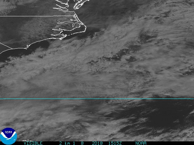
Sun Aug-28-05 10:52 AM
Response to Original message
58. Another photo. Look at that eye.
Printer Friendly | Permalink |  | Top
 
Sgent Donating Member (1000+ posts) Send PM | Profile | Ignore Sun Aug-28-05 10:55 AM
Response to Original message
60. WWL
2 X Refinaries in St. Benard have ceased operations...
Printer Friendly | Permalink |  | Top
 
pfitz59 Donating Member (1000+ posts) Send PM | Profile | Ignore Sun Aug-28-05 11:07 AM
Response to Original message
63. Is Boy George still on vacation?
or is he personally mustering disaster aid from neighboring states? My guess he's gone for another bike ride.....
Printer Friendly | Permalink |  | Top
 
54anickel Donating Member (1000+ posts) Send PM | Profile | Ignore Sun Aug-28-05 11:11 AM
Response to Reply #63
64. Comin' out on TeeVee at 12:30 EST, followed by "watch this drive" n/t
Printer Friendly | Permalink |  | Top
 
MilesColtrane Donating Member (1000+ posts) Send PM | Profile | Ignore Sun Aug-28-05 11:12 AM
Response to Reply #63
65. After this thing hits, Il Douche plans on
"staying the course" and getting on with his vacation.
Printer Friendly | Permalink |  | Top
 
DLnyc Donating Member (1000+ posts) Send PM | Profile | Ignore Sun Aug-28-05 11:44 AM
Response to Reply #65
73. slime Katrina?
I dunno. Seems like Katrina has taken some of the excitement out of shrubbie's Iraq announcement. Of course it's much more important to have a PR stunt today than to worry about thousands of endangered lives along the Gulf coast.

Guess we can expect Rove to start spreading stories about Katrina's secret lesbian affairs later today. Maybe they will also try to slime Mother Nature.
Printer Friendly | Permalink |  | Top
 
MiniMe Donating Member (1000+ posts) Send PM | Profile | Ignore Sun Aug-28-05 12:12 PM
Response to Reply #63
83. Well, he DOES have to get on with his life.
/sarcasm off
Printer Friendly | Permalink |  | Top
 
Ilsa Donating Member (1000+ posts) Send PM | Profile | Ignore Sun Aug-28-05 11:42 AM
Response to Original message
72. Hurricane KATRINA: 175 MPH Max Sustained Winds
Edited on Sun Aug-28-05 11:43 AM by Ilsa
Snip

REPEATING THE 10 AM CDT POSITION...26.0 N... 88.1 W. MOVEMENT

TOWARD...WEST-NORTHWEST NEAR 12 MPH. MAXIMUM SUSTAINED WINDS...

175 MPH.
MINIMUM CENTRAL PRESSURE... 907 MB.


AN INTERMEDIATE ADVISORY WILL BE ISSUED BY THE NATIONAL HURRICANE

CENTER AT 1 PM CDT FOLLOWED BY THE NEXT COMPLETE ADVISORY AT 4 PM

CDT.


FORECASTER PASCH

http://www.boatus.com/hurricanes/hurricane_advisory.asp

Printer Friendly | Permalink |  | Top
 
Endangered Specie Donating Member (1000+ posts) Send PM | Profile | Ignore Sun Aug-28-05 11:59 AM
Response to Reply #72
78. Holy shit 175 MPH... thats pratically unheard of in a Hurricane!
Printer Friendly | Permalink |  | Top
 
MiniMe Donating Member (1000+ posts) Send PM | Profile | Ignore Sun Aug-28-05 12:52 PM
Response to Reply #72
86. Pressure now down to 906mb
Per the Weather channel. Just heard it.
Printer Friendly | Permalink |  | Top
 
Dover Donating Member (1000+ posts) Send PM | Profile | Ignore Sun Aug-28-05 11:54 AM
Response to Original message
75. Question for those experienced in emergency care......
Edited on Sun Aug-28-05 12:06 PM by Dover
How can we, in surrounding states, get prepared to help with this impending disaster? I have no medical skills but wonder how I can get prepared to help (without getting in the way of emergency organizations)?

Also curious if anyone remembers what the sustained winds were for Hurricane Andrew, for comparison.
Printer Friendly | Permalink |  | Top
 
skip fox Donating Member (1000+ posts) Send PM | Profile | Ignore Sun Aug-28-05 11:57 AM
Response to Original message
76. This is a monster! I hope the mods allow multiple strings in LBN and
elsewhere various aspects: damage, projections, traffic, power outages, deaths, curfews, etc., as the articles linked will be on these aspects and DUers in the area and those who know those of us in the area can easily find the information they need.

Maximum amount of accurate information is strongly desired and useful to many of us and our friends.

I'm in Lafayette, LA, and should be spared more than 39 mph winds.
Printer Friendly | Permalink |  | Top
 
nothingshocksmeanymore Donating Member (1000+ posts) Send PM | Profile | Ignore Sun Aug-28-05 12:12 PM
Response to Reply #76
82. I was wondering about that...so so far Lafayette is not expected
to get hit hard?
Printer Friendly | Permalink |  | Top
 
Danmel Donating Member (1000+ posts) Send PM | Profile | Ignore Sun Aug-28-05 01:02 PM
Response to Original message
88. Gusts of 213 miles per hour!
I have never heard of wind that high. Scary scary scary! They said on the news that if the storm surges are about 20 feet as predicted, portions of the city could be submerged for 6 months! Absolutely terrifying. I am really scared for the people there. I don't even know what to say- I just hope they get most of the people out of there. Looks like it could really be devastating. Praying and I'm not really a praying kind of girl.
Printer Friendly | Permalink |  | Top
 
Moderator DU Moderator Donating Member (1000+ posts) Send PM | Profile | Ignore Sun Aug-28-05 01:02 PM
Response to Original message
89. UPDATED THREAD
Printer Friendly | Permalink |  | Top
 
DU AdBot (1000+ posts) Click to send private message to this author Click to view 
this author's profile Click to add 
this author to your buddy list Click to add 
this author to your Ignore list Thu Apr 25th 2024, 06:38 PM
Response to Original message
Advertisements [?]
 Top

Home » Discuss » Latest Breaking News Donate to DU

Powered by DCForum+ Version 1.1 Copyright 1997-2002 DCScripts.com
Software has been extensively modified by the DU administrators


Important Notices: By participating on this discussion board, visitors agree to abide by the rules outlined on our Rules page. Messages posted on the Democratic Underground Discussion Forums are the opinions of the individuals who post them, and do not necessarily represent the opinions of Democratic Underground, LLC.

Home  |  Discussion Forums  |  Journals |  Store  |  Donate

About DU  |  Contact Us  |  Privacy Policy

Got a message for Democratic Underground? Click here to send us a message.

© 2001 - 2011 Democratic Underground, LLC