| Latest | Greatest | Lobby | Journals | Search | Options | Help | Login |
|
|
|
This topic is archived. |
| Home » Discuss » Archives » General Discussion (1/22-2007 thru 12/14/2010) |
|
| DemoTex
|
Tue Jun-15-10 12:08 AM Original message |
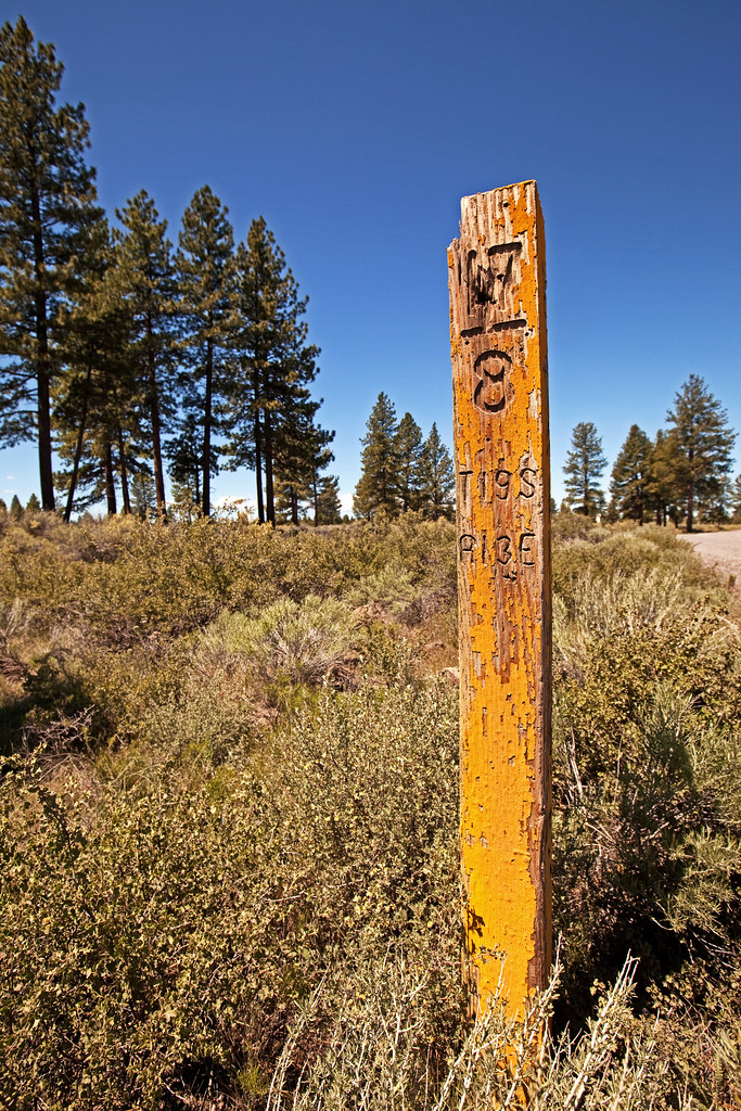
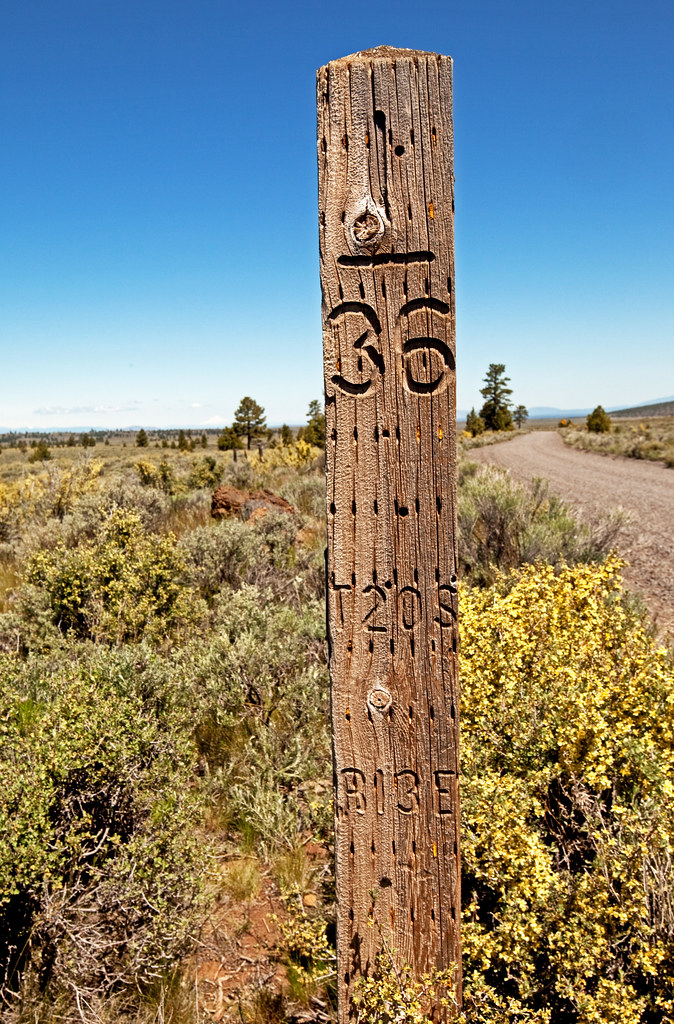
| Image riddle for DU: What are these? |
| Printer Friendly | Permalink | | Top |
| nadinbrzezinski
|
Tue Jun-15-10 12:10 AM Response to Original message |
| 1. Hmm they look like the mine claim markers |
| Printer Friendly | Permalink | | Top |
| jotsy
|
Tue Jun-15-10 12:19 AM Response to Reply #1 |
| 9. Wondered if you were OK after news of So Cal quakes. |
| Printer Friendly | Permalink | | Top |
| nadinbrzezinski
|
Tue Jun-15-10 12:23 AM Response to Reply #9 |
| 11. We are fine |
| Printer Friendly | Permalink | | Top |
| DemoTex
|
Tue Jun-15-10 12:52 AM Response to Reply #11 |
| 24. First I have heard of a quake |
| Printer Friendly | Permalink | | Top |
| nadinbrzezinski
|
Tue Jun-15-10 12:55 AM Response to Reply #24 |
| 26. Happened tonight |
| Printer Friendly | Permalink | | Top |
| jotsy
|
Tue Jun-15-10 01:17 AM Response to Reply #11 |
| 27. I shall rest easier then, thanks. |
| Printer Friendly | Permalink | | Top |
| CaliforniaPeggy
|
Tue Jun-15-10 12:11 AM Response to Original message |
| 2. My dear DemoTex! |
| Printer Friendly | Permalink | | Top |
| DemoTex
|
Tue Jun-15-10 12:22 AM Response to Reply #2 |
| 10. Very close, Peg! |
| Printer Friendly | Permalink | | Top |
| petronius
|
Tue Jun-15-10 12:11 AM Response to Original message |
| 3. I know! I know! They're targets, like every other upright object in the wilderness! |
| Printer Friendly | Permalink | | Top |
| DemoTex
|
Tue Jun-15-10 12:34 AM Response to Reply #3 |
| 19. Eggs-actly! |
| Printer Friendly | Permalink | | Top |
| csziggy
|
Tue Jun-15-10 12:12 AM Response to Original message |
| 4. Survey markers - not sure of the real name |
| Printer Friendly | Permalink | | Top |
| DemoTex
|
Tue Jun-15-10 12:29 AM Response to Reply #4 |
| 15. Yep |
| Printer Friendly | Permalink | | Top |
| nadinbrzezinski
|
Tue Jun-15-10 12:32 AM Response to Reply #15 |
| 18. Interesting |
| Printer Friendly | Permalink | | Top |
| blondeatlast
|
Tue Jun-15-10 12:53 AM Response to Reply #15 |
| 25. I remember those from the Kansas countryside. Ah, nostalgia... nt |
| Printer Friendly | Permalink | | Top |
| csziggy
|
Tue Jun-15-10 01:21 AM Response to Reply #15 |
| 28. Growing up the daughter of an engineer and surveyer is educational |
| Printer Friendly | Permalink | | Top |
| DemoTex
|
Tue Jun-15-10 01:28 AM Response to Reply #28 |
| 29. Which begs the question: why not standardize? |
| Printer Friendly | Permalink | | Top |
| csziggy
|
Tue Jun-15-10 01:48 AM Response to Reply #29 |
| 30. I think it will all be moving to Lat/Long |
| Printer Friendly | Permalink | | Top |
| nadinbrzezinski
|
Tue Jun-15-10 07:01 PM Response to Reply #30 |
| 36. When I did rescue work in Mexico |
| Printer Friendly | Permalink | | Top |
| csziggy
|
Tue Jun-15-10 07:09 PM Response to Reply #36 |
| 38. All our topos are upstairs, but I think they do all (and always have had) Lat/Long |
| Printer Friendly | Permalink | | Top |
| blogslut
|
Tue Jun-15-10 12:13 AM Response to Original message |
| 5. Water markers |
| Printer Friendly | Permalink | | Top |
| Lasher
|
Tue Jun-15-10 12:13 AM Response to Original message |
| 6. Highway markers |
| Printer Friendly | Permalink | | Top |
| Obamanaut
|
Tue Jun-15-10 12:14 AM Response to Original message |
| 7. Look a bit like survey or boundary markers. I've seen similar markings |
| Printer Friendly | Permalink | | Top |
| Psephos
|
Tue Jun-15-10 12:16 AM Response to Original message |
| 8. Look like old Public Land Survey System markers. n/t |
| Printer Friendly | Permalink | | Top |
| DemoTex
|
Tue Jun-15-10 12:40 AM Response to Reply #8 |
| 21. Another winner! |
| Printer Friendly | Permalink | | Top |
| Cresent City Kid
|
Tue Jun-15-10 12:26 AM Response to Original message |
| 12. They don't look like property corners, |
| Printer Friendly | Permalink | | Top |
| mitchum
|
Tue Jun-15-10 12:27 AM Response to Original message |
| 13. Firewood |
| Printer Friendly | Permalink | | Top |
| DemoTex
|
Tue Jun-15-10 12:43 AM Response to Reply #13 |
| 22. No, but that gives me an idea .. |
| Printer Friendly | Permalink | | Top |
| XemaSab
|
Tue Jun-15-10 12:29 AM Response to Original message |
| 14. Township and range markers |
| Printer Friendly | Permalink | | Top |
| DemoTex
|
Tue Jun-15-10 12:31 AM Response to Reply #14 |
| 16. 10-4 |
| Printer Friendly | Permalink | | Top |
| XemaSab
|
Tue Jun-15-10 12:38 AM Response to Reply #16 |
| 20. . |
| Printer Friendly | Permalink | | Top |
| xxqqqzme
|
Tue Jun-15-10 12:31 AM Response to Original message |
| 17. Alien landing site markers? |
| Printer Friendly | Permalink | | Top |
| DemoTex
|
Tue Jun-15-10 12:50 AM Response to Reply #17 |
| 23. Could be .. |
| Printer Friendly | Permalink | | Top |
| JDPriestly
|
Tue Jun-15-10 01:49 AM Response to Original message |
| 31. Snow markers? |
| Printer Friendly | Permalink | | Top |
| Uben
|
Tue Jun-15-10 04:17 AM Response to Original message |
| 32. Grave markers for alpha-numeric cavemen? |
| Printer Friendly | Permalink | | Top |
| Kablooie
|
Tue Jun-15-10 11:35 AM Response to Original message |
| 33. They are ancient road markings from when California was part of the Roman empire. |
| Printer Friendly | Permalink | | Top |
| Greyhound
|
Tue Jun-15-10 12:26 PM Response to Original message |
| 34. Monuments? n/t |
| Printer Friendly | Permalink | | Top |
| RushIsRot
|
Tue Jun-15-10 12:52 PM Response to Original message |
| 35. Township 19 South, Range 13 East, Township 20 South, Range 13 East |
| Printer Friendly | Permalink | | Top |
| DemoTex
|
Tue Jun-15-10 11:34 PM Response to Reply #35 |
| 40. Very close to the cigar .. |
| Printer Friendly | Permalink | | Top |
| branders seine
|
Tue Jun-15-10 07:08 PM Response to Original message |
| 37. section markers |
| Printer Friendly | Permalink | | Top |
| spanone
|
Tue Jun-15-10 07:10 PM Response to Original message |
| 39. k&r |
| Printer Friendly | Permalink | | Top |
| DU
AdBot (1000+ posts) |
Thu May 02nd 2024, 09:47 AM Response to Original message |
| Advertisements [?] |
| Top |
| Home » Discuss » Archives » General Discussion (1/22-2007 thru 12/14/2010) |
|
Powered by DCForum+ Version 1.1 Copyright 1997-2002 DCScripts.com
Software has been extensively modified by the DU administrators
Important Notices: By participating on this discussion board, visitors agree to abide by the rules outlined on our Rules page. Messages posted on the Democratic Underground Discussion Forums are the opinions of the individuals who post them, and do not necessarily represent the opinions of Democratic Underground, LLC.
Home | Discussion Forums | Journals | Store | Donate
About DU | Contact Us | Privacy Policy
Got a message for Democratic Underground? Click here to send us a message.
© 2001 - 2011 Democratic Underground, LLC