Almost all of my family and friends on the East coast are right in the path of the storm according to the tracker I have been watching. On Long Island, North Carolina, New Jersey (they always seem to get the worst of these storms) and New York City. Almost all, except for those in NJ and NYC, are on or near the water. I am really worried about Long Island.
On the map below, from where the Island splits into two tails, going west, it becomes more and more populated. As you travel closer to the city, it is very highly populated and much of the population lives near or on the water, the South side on the Atlantic, the North on The Long Island Sound. This means millions of people who will be affected.
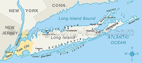
As you go east, away from NYC, LI splits into two forks a bit more than half way out, the North and South (the Hamptons are on the South Fork and so is Montauk Point. The South Fork is on the Atlantic Ocean side.
The North Fork is between the Long Island Sound and Peconic Bay. At the tip of the North Fork is Orient Point, where the big ferries leave for New London every day. I may be wrong, but the way the storm is tracking, it looks like the South Fork will take the brunt of the storm from the Atlantic side.
There are so many homes right on the Atlantic, stretching for miles and miles. Further in towards NYC the Island is much more populated with a lot more homes on the water on both the North and South Shores. There are also canals and lakes etc. If it remains as big as it is, I think many of those homes will be swept away. It would not be the first time.
But many locals whose families have there for generations, have been saying for several years now that the Island is due for a 'big one' and when it comes, it could wash away the entire tip of the South Shore, Montauk Point. There the Atlantic Ocean meets the LI Sound and even without a Hurricane fishing out there is an adventure. A storm churning up those two big bodies of water will be disastrous, imo. Everyone needs to evacuate. And they should do so tomorrow as there is only one way out and that will be filled with traffic. Even on a normal weekend it is difficult to get back to the city from that area on a summer weekend.
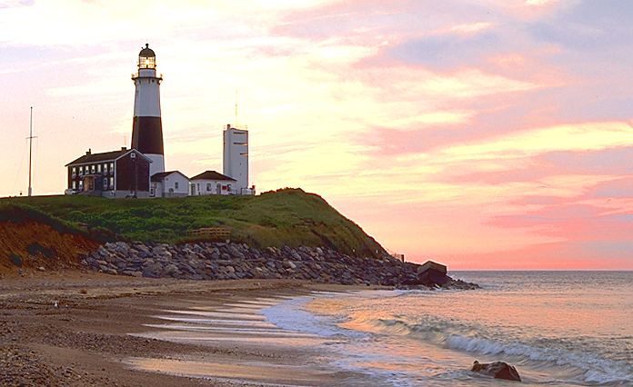 Montauk Point on the Southern Tip of the South Fork on LI.
We have been there so often, it is truly beautiful. I would be heartbroken as would everyone else, if the Lighthouse does not survive. It is the pride and joy of so many of the local people.
The Lighthouse has been restored with funds raised every year by people like Paul Simon and other celebrities. The town, the fishing boats, the whole area is beautiful. Not too far to the west of the Point, I have friends who live right on Peconic Bay in Noyac. I hope their house survives and I hope they leave.
This was where many people think the book 'Jaws' was written about.
On the North Fork, there are also many homes on the way out to Orient Point. There is also several towns and villages, Greenport being one of the bigger towns and right on the water. They will not lose power as they have their own generator and most people will be going there to eat etc. after the storm. Anyone out there will have to leave also. Little villages will probably be flooded as nowhere out there is too far from the water.
 Orient Point on the Northern Tip of the North Fork of LI
And that's just one relatively small Island populated by millions of people. Millions more all along the coast and in NYC itself and the boroughs, all will be affected in one way or another. And of course there are other smaller islands that are populated, like Block Island in the LI Sound eg.
My sister and her family live on the North Fork of LI, about a block from Peconic Bay. So far, she is not planning to evacuate.
